September 14, 2015
I woke up just after 6:00 and got up, thinking I would make
some coffee and wash my dishes from the night before. As I was hiking to the restroom, it started
to rain. Thinking about the wash I
would have to cross to get out of the canyon, I abandoned all previous plans,
packed up my tent, and got out of there by 7:30. I made tracks down the nasty dirt road and
got over the wash while it was still dry.
I hadn’t had time to look at a map or plan my route, so I turned south
on 550, planning to stop at the nearest diner to eat breakfast and
regroup. Ha! I drove for 65 miles to the town of Cuba, NM,
before I found anywhere to eat. By then
I had already passed the road to Taos.
Actually, the shortest route would have been to go NORTH on 550, but it
was much too late for that. I got coffee
and breakfast at McDonalds and then turned back and retraced my steps to
Highway 96. The drive was pleasant
enough and, although the road looked mountainous on the map, it wasn’t particularly
curvy. I eventually made my way across
to the Rio Grande Valley and headed north into Taos. I was very tired and just wanted to go to my
hostel and take a nap.
 |
| The Abominable Snowmansion |
I had a reservation at the Abominable Snowmansion Hostel
which is located in Arroyo Seco, seven or eight miles up Highway 150 towards
Taos Ski Valley. When I got up there
just after 1:00, I discovered that the hostel did not open until 4:00. I wasn’t in the mood for exploring Taos, so I
decided to get something to eat and look at my guidebooks. I had some very tasty chiles rellenos at the
Taos Diner and drank about three diet cokes, which returned me to some
semblance of consciousness. I decided to
spend the afternoon driving the Enchanted Circle, a loop through the mountains
above Taos. The scenery was pretty, but
I failed to be enchanted. Maybe I was
just tired or maybe I was jaded by a lifetime of mountain scenery. I did get rained on in Red River, which
washed off most of the dust I had picked up on the drive in and out of Chaco
Canyon.
 |
| Enchanted Circle Scenery |
It was 5:00 by the time I returned to the Abominable
Snowmansion and checked in. I was
assigned a private cabin, although I had to use a communal restroom. This saved me about $70 a night over hotels
in Taos, so was fine with me. While I
was too far from the main building to get the hostel’s internet, I got a good
signal from a nearby restaurant. Being a
hostel, there was a communal kitchen, so I was finally able to wash my dishes
from the night before. I had some
business to attend to and a blog post to write, so I spent the entire evening
in my cabin and just had a cheese sandwich and a banana for dinner.
 |
| My Cabin at the Abominable Snowmansion |
September 15, 2015
Despite having been the last person in the hostel to turn
out my light the night before, I was the first one up. I awakened to the sound of rain on my roof,
which was much more welcome without the prospect of crossing a flash flood
prone wash. I got up and took a shower
before anyone else was stirring. Since
the refrigerator in my room had frozen all my food solid, I drove into Taos and
got breakfast and coffee at the McDonalds there. I knew I needed inspiration if I was going to
get into the spirit of Taos, so I decided to take the historic trolley tour.

The tour left from the visitor center south of town and proceeded
to the plaza where we picked up some more passengers and listened to the guide
give us a short history of Taos. Then we
made a quick circuit of central Taos and headed out to Taos Pueblo. Taos Pueblo has been continuously inhabited
for 1,000 years and is the oldest continuously inhabited community in the
country, if not all of North America.
Today, the people of the pueblo also have modern homes, but they inhabit
their pueblo homes when the weather gets too hot or cold because the adobe is a
very good insulator. No electricity or
running water is allowed within the pueblo, but some propane appliances are
allowed because they require no modifications to the structure. All water comes from the creek that runs
through the pueblo. The tribe owns the
watershed and can make sure that the water remains pure. They test the water quality weekly.
 |
| Bell Tower |
When the Spanish first arrived in Taos in the late 16th
century, they got along well with the natives. Unfortunately, by 1680 they had begun to
try to tell the natives what to do, so the natives ran them out and chased them
all the way to El Paso. The Spanish
government would not be dissuaded from colonizing the area, however, and by the
early 18th century, they were back.
Things went better this time and another period of peaceful coexistence
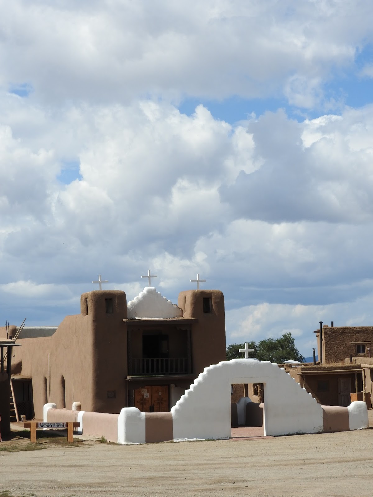
followed, during which the majority of the natives accepted Christianity. The church of San Geronimo was erected at the
pueblo. Things got out of hand, however,
when the United States took over the New Mexico territory and sent a new
governor who, once again, tried to tell the people what to do. The natives dragged him out of his house and
killed him. Then the U.S. government
sent the cavalry, who turned their cannons on the church of San Geronimo, not
knowing (or perhaps not caring) that 150 people were hiding within. The church was destroyed and the people
inside were killed. Today, all that
remains of the original church is the bell tower. The site of the church is now a graveyard
where the victims were buried. A new
church was constructed nearby.
 |
| Graveyard |
 |
| New Church of San Geronimo |
Taos Pueblo consists of two great houses, North House and
South House, and some smaller surrounding buildings, all of adobe. Because adobe is constantly eroded by sun,
wind, and rain, they must all be re-mudded every year. Men were busy working on North House during
my visit. Many of the homes have been
turned into shops and restaurants, which were surprisingly spacious and
pleasant inside. Skylights have replaced
some of the original doors, which were always in the ceiling until the 19th
century when the tribe felt secure enough to add ground level doors. If you want to take pictures at Taos Pueblo,
you must buy a camera permit for $6.
 |
| Taos Pueblo North House |
 |
| Fresh Mud on North House |
From Taos Pueblo, we drove out to the Mar-tinez Ha-cienda,
which was a major center of trade during the 18
th and 19
th
centuries. The priest who converted the
natives was the eldest son of the hacienda’s founder. Today, it houses a museum, which we did not
get a chance to visit. Unfortunately, we
didn’t even get to look at it much because it began to rain heavily just as we
got out of the trolley.
 |
| St. Francis of Asisi Church |
Our last stop was the St. Francis of Asisi Church in the
suburb of Ranchos. This is the famous
church frequently photographed and painted.
The congregation re-muds the church every June, but this year has been
especially rainy, so they will be re-mudding it a second time in November. It is very carefully maintained and looks
lovely.
 |
| Rear of St. Francis of Asisi |
Not wanting to eat a big lunch, I grabbed a couple of tacos
and visited the ATM (There is no Bank of America within 50 miles of Taos.) Then I made a brief survey of the shops
surrounding the plaza and ducked into the Harwood Museum of Art just as it
began to rain. The museum is on Ledoux
Street, which also houses many galleries and some of the homes of the original
members of the Taos Society of Artists.
Taos became an art community when, in 1898, painters Bert Phillips and
Ernest Blumenschein passed through Taos on their way from Denver to Mexico on a
painting trip. They were intrigued with
the culture and the light and Phillips stayed permanently, Soon, they attracted other artists. By 1915, a number of these early artists
founded the Taos Society of Artists. To
be a member, an artist had to have been working in Taos for three years and be
accepted by the existing membership. The
Harwood Museum was originally the home of Burt and Elizabeth Harwood. When Burt died in 1922, his wife and other
artists of the society established the Harwood Foundation in his honor. Today, the museum belongs to the University of
New Mexico and displays work from the original artists as well as more
contemporary Taos works.
 |
| Bridge Over the Rio Grande |
It was late afternoon when I left the museum and still
threatening to rain, so I decided that it
was a good time to do a little wine tasting.
I dropped into the Black Mesa Tasting Room and spent a pleasant couple
of hours tasting New Mexican wines and chatting with the winemaker and a couple
I had met earlier on the tour. When the
live music started up, it got too noisy for me, so I left to drive out the
bridge over the Rio Grande, which I wanted to photograph at sunset. I parked at the rest stop on the far side of
the bridge (which was locked up tight) and walked down towards the perimeter
fence to take pictures of the bridge.
While I was fiddling with my camera, something walked into my viewfinder
and I was astonished to see a large bighorn ram. He wasn’t the least bit disturbed by me and I
got several pictures of him and, eventually, a second ram appeared behind him. The bridge was forgotten and I never did got
my sunset shot.

On my way back to the hostel from the bridge, I stopped at
the Taos Brewing Company because everyone had told me the food and beer were
good. I had a tasty pulled pork sandwich
and a pint of their Fall Down Brown, which was actually the least alcoholic
beer they served at just 4.6% alcohol.
By the time I left it was pitch dark and I could barely find my way out
of the parking lot. It seemed I hadn’t
seen a moon since I left Benicia. I
drove back to Arroyo Seco with my high beams on most of the way. It was 9:00 when I returned to the hostel
and, unlike the night before when a large group had been partying around the
firepit, the place was still as a tomb.
I headed straight for my cabin and settled in to chronicle the day.
September 16, 2015
I didn’t have far to drive, so I took my time and cooked
breakfast in the hostel kitchen before driving back into Taos to get a cup of
coffee and go on a fruitless search for a block of ice. Eventually, I learned that the Taos ice
company had stopped making blocks of ice, so there were none to be had. I filled my car with gas and drove through a
car wash to remove the dirt road dust that had become mud in the rain. Then I headed south through town until I
picked up the high road to Santa Fe, which is marked as the high road to Taos,
even in the opposite direction.
 |
| High Road to Santa Fe Scene |
The high road to Taos passed through pretty scenery. By noon, I was in Santa Fe. It was too early to check into my hotel, so I
went straight downtown to visit the Georgia O’Keefe museum. Unfortunately, the museum was closed for the
next week. That was disappointing. I settled for visiting the New Mexico Museum
of Art. The building, which was built in
the second decade of the twentieth century, was a fabulous example of pueblo
revival architecture. The collection was
also impressive and I was happy to see that there was an exhibition of Georgia
O’Keefe pieces. I was impressed by some
incredibly detailed chalk pastel pieces and some Daughtery pieces that looked
like Van Gogh had visited New Mexico.
The collection was large and it was 3:00 by the time I finished touring
the museum.
 |
| New Mexico Museum of Art |
 |
| My Favorite Painting |
 |
| Did Van Gogh Visit New Mexico? |
After the museum, I walked across the street to the plaza
and ate a green chile cheeseburger at the Thunderbird Bar & Grill with a
deck overlooking the plaza. The plaza
seemed very Mexican, although overrun by gringos. Interestingly, the gringos were hanging out
in the plaza just like Mexicans do.
Santa Fe requires that all buildings be in the pueblo style. On one side of the plaza is the Palace of the
Governors, the oldest public building in the United States, which dates back to
1610 when it was the home of the first Spanish Governor of New Mexico. At the far end, was the St. Francis
Cathedral. This Romanesque cathedral was
built with money donated by a local Jewish merchant who had befriended Bishop
Lamy on their way
 |
| St. Francis Cathedral |
 |
| Palace of the Governors |
across the country. He
made a fortune providing saddles and uniforms to the Union Army and helped his
friend the bishop finish the cathedral when he ran out of money. Later, he forgave the debt.
Since I felt like I was in Mexico, I did what
I would do in Mexico and bought an ice cream while I window shopped around the
plaza. I was very tempted to buy a pair
of fancy cowboy boots, but knew I would never be able to walk in them since I
have lousy feet. When things began to
close for the evening, I repaired to the Santa Fe Suites where I had reserved a
room. The Santa Fe Suites was a great
value. For the price of my tiny cabin
with a communal bathroom in Taos, I got a hotel room with a kitchenette. It was nice to relax and spend an evening
watching TV.
 I got up and made myself coffee in my little kitchen and ate
the last of my bagels and cream cheese.
I spent a little bit of time dealing with personal business and then hit
the road about 10:00, after another fruitless search for block ice. From Santa Fe, I headed south on Highway
285. New Mexico’s slogan may be, “Land
of Enchantment,” but I call it the Land of Post Offices. There is a post office trailer in every
little hamlet in New Mexico. It is very
rural and they must not have home delivery.
Living in California where they are closing post offices right and left,
it was strange to see so many of
I got up and made myself coffee in my little kitchen and ate
the last of my bagels and cream cheese.
I spent a little bit of time dealing with personal business and then hit
the road about 10:00, after another fruitless search for block ice. From Santa Fe, I headed south on Highway
285. New Mexico’s slogan may be, “Land
of Enchantment,” but I call it the Land of Post Offices. There is a post office trailer in every
little hamlet in New Mexico. It is very
rural and they must not have home delivery.
Living in California where they are closing post offices right and left,
it was strange to see so many of 
 them.
There was not a whole lot to see between Santa Fe and Alamo-gordo. The scenery changed gradually, but was all
open spaces. I was driving through Billy
the Kid Country. I stopped for lunch in
Tularosa, forgetting that here, red sauce is the very spicy one. I ordered a smothered burrito and got meat
and potatoes wrapped in a tortilla and smothered with fiery red sauce and lots
of cheese. There were no vegetables in
sight.
them.
There was not a whole lot to see between Santa Fe and Alamo-gordo. The scenery changed gradually, but was all
open spaces. I was driving through Billy
the Kid Country. I stopped for lunch in
Tularosa, forgetting that here, red sauce is the very spicy one. I ordered a smothered burrito and got meat
and potatoes wrapped in a tortilla and smothered with fiery red sauce and lots
of cheese. There were no vegetables in
sight.


 I eventually found the park and, after a quick stop at the
visitor center, I took the eight mile loop drive through the saguaro forest,
making frequent stops to take photographs.
The park was founded in 1933 to protect the saguaro forest, but in the
1960s there were a couple of hard freezes and many of them died off. Saguaro lovers became concerned because no
new cacti were growing to take the place of the ones that had died. A saguaro grows very slowly and takes 150
years to mature and 70 or 80 years before it starts to branch. Finally, the park service bought out the
grazing rights to the park and eliminated cattle from the property. With no cattle to trample the seedlings, the
saguaros began to make a comeback. While
there aren’t as many as there were in the 1930s, there are a lot of young ones
that will eventually be impressive.
I eventually found the park and, after a quick stop at the
visitor center, I took the eight mile loop drive through the saguaro forest,
making frequent stops to take photographs.
The park was founded in 1933 to protect the saguaro forest, but in the
1960s there were a couple of hard freezes and many of them died off. Saguaro lovers became concerned because no
new cacti were growing to take the place of the ones that had died. A saguaro grows very slowly and takes 150
years to mature and 70 or 80 years before it starts to branch. Finally, the park service bought out the
grazing rights to the park and eliminated cattle from the property. With no cattle to trample the seedlings, the
saguaros began to make a comeback. While
there aren’t as many as there were in the 1930s, there are a lot of young ones
that will eventually be impressive.