Friday, September 18, 2015

TAOS AND SANTA FE

September 14, 2015

I woke up just after 6:00 and got up, thinking I would make some coffee and wash my dishes from the night before.  As I was hiking to the restroom, it started to rain.  Thinking about the wash I would have to cross to get out of the canyon, I abandoned all previous plans, packed up my tent, and got out of there by 7:30.  I made tracks down the nasty dirt road and got over the wash while it was still dry.  I hadn’t had time to look at a map or plan my route, so I turned south on 550, planning to stop at the nearest diner to eat breakfast and regroup.  Ha!  I drove for 65 miles to the town of Cuba, NM, before I found anywhere to eat.  By then I had already passed the road to Taos.  Actually, the shortest route would have been to go NORTH on 550, but it was much too late for that.  I got coffee and breakfast at McDonalds and then turned back and retraced my steps to Highway 96.  The drive was pleasant enough and, although the road looked mountainous on the map, it wasn’t particularly curvy.  I eventually made my way across to the Rio Grande Valley and headed north into Taos.  I was very tired and just wanted to go to my hostel and take a nap.

The Abominable Snowmansion
I had a reservation at the Abominable Snowmansion Hostel which is located in Arroyo Seco, seven or eight miles up Highway 150 towards Taos Ski Valley.  When I got up there just after 1:00, I discovered that the hostel did not open until 4:00.  I wasn’t in the mood for exploring Taos, so I decided to get something to eat and look at my guidebooks.  I had some very tasty chiles rellenos at the Taos Diner and drank about three diet cokes, which returned me to some semblance of consciousness.  I decided to spend the afternoon driving the Enchanted Circle, a loop through the mountains above Taos.  The scenery was pretty, but I failed to be enchanted.  Maybe I was just tired or maybe I was jaded by a lifetime of mountain scenery.  I did get rained on in Red River, which washed off most of the dust I had picked up on the drive in and out of Chaco Canyon.
Enchanted Circle Scenery

It was 5:00 by the time I returned to the Abominable Snowmansion and checked in.  I was assigned a private cabin, although I had to use a communal restroom.  This saved me about $70 a night over hotels in Taos, so was fine with me.  While I was too far from the main building to get the hostel’s internet, I got a good signal from a nearby restaurant.  Being a hostel, there was a communal kitchen, so I was finally able to wash my dishes from the night before.  I had some business to attend to and a blog post to write, so I spent the entire evening in my cabin and just had a cheese sandwich and a banana for dinner.

My Cabin at the Abominable Snowmansion


September 15, 2015

Despite having been the last person in the hostel to turn out my light the night before, I was the first one up.  I awakened to the sound of rain on my roof, which was much more welcome without the prospect of crossing a flash flood prone wash.  I got up and took a shower before anyone else was stirring.  Since the refrigerator in my room had frozen all my food solid, I drove into Taos and got breakfast and coffee at the McDonalds there.  I knew I needed inspiration if I was going to get into the spirit of Taos, so I decided to take the historic trolley tour.

The tour left from the visitor center south of town and proceeded to the plaza where we picked up some more passengers and listened to the guide give us a short history of Taos.  Then we made a quick circuit of central Taos and headed out to Taos Pueblo.  Taos Pueblo has been continuously inhabited for 1,000 years and is the oldest continuously inhabited community in the country, if not all of North America.  Today, the people of the pueblo also have modern homes, but they inhabit their pueblo homes when the weather gets too hot or cold because the adobe is a very good insulator.  No electricity or running water is allowed within the pueblo, but some propane appliances are allowed because they require no modifications to the structure.  All water comes from the creek that runs through the pueblo.  The tribe owns the watershed and can make sure that the water remains pure.  They test the water quality weekly.
Bell Tower
                  
When the Spanish first arrived in Taos in the late 16th century, they got along well with the natives.    Unfortunately, by 1680 they had begun to try to tell the natives what to do, so the natives ran them out and chased them all the way to El Paso.  The Spanish government would not be dissuaded from colonizing the area, however, and by the early 18th century, they were back.  Things went better this time and another period of peaceful coexistence followed, during which the majority of the natives accepted Christianity.  The church of San Geronimo was erected at the pueblo.  Things got out of hand, however, when the United States took over the New Mexico territory and sent a new governor who, once again, tried to tell the people what to do.  The natives dragged him out of his house and killed him.  Then the U.S. government sent the cavalry, who turned their cannons on the church of San Geronimo, not knowing (or perhaps not caring) that 150 people were hiding within.  The church was destroyed and the people inside were killed.  Today, all that remains of the original church is the bell tower.  The site of the church is now a graveyard where the victims were buried.  A new church was constructed nearby.
Graveyard


New Church of San Geronimo
Taos Pueblo consists of two great houses, North House and South House, and some smaller surrounding buildings, all of adobe.  Because adobe is constantly eroded by sun, wind, and rain, they must all be re-mudded every year.  Men were busy working on North House during my visit.  Many of the homes have been turned into shops and restaurants, which were surprisingly spacious and pleasant inside.  Skylights have replaced some of the original doors, which were always in the ceiling until the 19th century when the tribe felt secure enough to add ground level doors.  If you want to take pictures at Taos Pueblo, you must buy a camera permit for $6.
Taos Pueblo North House
Fresh Mud on North House
From Taos Pueblo, we drove out to the Mar-tinez Ha-cienda, which was a major center of trade during the 18th and 19th centuries.  The priest who converted the natives was the eldest son of the hacienda’s founder.  Today, it houses a museum, which we did not get a chance to visit.  Unfortunately, we didn’t even get to look at it much because it began to rain heavily just as we got out of the trolley.

St. Francis of Asisi Church
Our last stop was the St. Francis of Asisi Church in the suburb of Ranchos.  This is the famous church frequently photographed and painted.  The congregation re-muds the church every June, but this year has been especially rainy, so they will be re-mudding it a second time in November.  It is very carefully maintained and looks lovely.

Rear of St. Francis of Asisi
Not wanting to eat a big lunch, I grabbed a couple of tacos and visited the ATM (There is no Bank of America within 50 miles of Taos.)  Then I made a brief survey of the shops surrounding the plaza and ducked into the Harwood Museum of Art just as it began to rain.  The museum is on Ledoux Street, which also houses many galleries and some of the homes of the original members of the Taos Society of Artists.  Taos became an art community when, in 1898, painters Bert Phillips and Ernest Blumenschein passed through Taos on their way from Denver to Mexico on a painting trip.  They were intrigued with the culture and the light and Phillips stayed permanently,  Soon, they attracted other artists.  By 1915, a number of these early artists founded the Taos Society of Artists.  To be a member, an artist had to have been working in Taos for three years and be accepted by the existing membership.  The Harwood Museum was originally the home of Burt and Elizabeth Harwood.  When Burt died in 1922, his wife and other artists of the society established the Harwood Foundation in his honor.  Today, the museum belongs to the University of New Mexico and displays work from the original artists as well as more contemporary Taos works.


Bridge Over the Rio Grande
It was late afternoon when I left the museum and still threatening to rain, so I decided that it was a good time to do a little wine tasting.  I dropped into the Black Mesa Tasting Room and spent a pleasant couple of hours tasting New Mexican wines and chatting with the winemaker and a couple I had met earlier on the tour.  When the live music started up, it got too noisy for me, so I left to drive out the bridge over the Rio Grande, which I wanted to photograph at sunset.  I parked at the rest stop on the far side of the bridge (which was locked up tight) and walked down towards the perimeter fence to take pictures of the bridge.  While I was fiddling with my camera, something walked into my viewfinder and I was astonished to see a large bighorn ram.  He wasn’t the least bit disturbed by me and I got several pictures of him and, eventually, a second ram appeared behind him.  The bridge was forgotten and I never did got my sunset shot.

On my way back to the hostel from the bridge, I stopped at the Taos Brewing Company because everyone had told me the food and beer were good.  I had a tasty pulled pork sandwich and a pint of their Fall Down Brown, which was actually the least alcoholic beer they served at just 4.6% alcohol.  By the time I left it was pitch dark and I could barely find my way out of the parking lot.  It seemed I hadn’t seen a moon since I left Benicia.  I drove back to Arroyo Seco with my high beams on most of the way.  It was 9:00 when I returned to the hostel and, unlike the night before when a large group had been partying around the firepit, the place was still as a tomb.  I headed straight for my cabin and settled in to chronicle the day.

September 16, 2015

I didn’t have far to drive, so I took my time and cooked breakfast in the hostel kitchen before driving back into Taos to get a cup of coffee and go on a fruitless search for a block of ice.  Eventually, I learned that the Taos ice company had stopped making blocks of ice, so there were none to be had.  I filled my car with gas and drove through a car wash to remove the dirt road dust that had become mud in the rain.  Then I headed south through town until I picked up the high road to Santa Fe, which is marked as the high road to Taos, even in the opposite direction.

High Road to Santa Fe Scene
The high road to Taos passed through pretty scenery.  By noon, I was in Santa Fe.  It was too early to check into my hotel, so I went straight downtown to visit the Georgia O’Keefe museum.  Unfortunately, the museum was closed for the next week.  That was disappointing.  I settled for visiting the New Mexico Museum of Art.  The building, which was built in the second decade of the twentieth century, was a fabulous example of pueblo revival architecture.  The collection was also impressive and I was happy to see that there was an exhibition of Georgia O’Keefe pieces.  I was impressed by some incredibly detailed chalk pastel pieces and some Daughtery pieces that looked like Van Gogh had visited New Mexico.  The collection was large and it was 3:00 by the time I finished touring the museum.
New Mexico Museum of Art

My Favorite Painting

Did Van Gogh Visit New Mexico?


After the museum, I walked across the street to the plaza and ate a green chile cheeseburger at the Thunderbird Bar & Grill with a deck overlooking the plaza.  The plaza seemed very Mexican, although overrun by gringos.  Interestingly, the gringos were hanging out in the plaza just like Mexicans do.  Santa Fe requires that all buildings be in the pueblo style.  On one side of the plaza is the Palace of the Governors, the oldest public building in the United States, which dates back to 1610 when it was the home of the first Spanish Governor of New Mexico.  At the far end, was the St. Francis Cathedral.  This Romanesque cathedral was built with money donated by a local Jewish merchant who had befriended Bishop Lamy on their way
St. Francis Cathedral

Palace of the Governors
across the country.  He made a fortune providing saddles and uniforms to the Union Army and helped his friend the bishop finish the cathedral when he ran out of money.  Later, he forgave the debt.

 Since I felt like I was in Mexico, I did what I would do in Mexico and bought an ice cream while I window shopped around the plaza.  I was very tempted to buy a pair of fancy cowboy boots, but knew I would never be able to walk in them since I have lousy feet.  When things began to close for the evening, I repaired to the Santa Fe Suites where I had reserved a room.  The Santa Fe Suites was a great value.  For the price of my tiny cabin with a communal bathroom in Taos, I got a hotel room with a kitchenette.  It was nice to relax and spend an evening watching TV.

Wednesday, September 16, 2015

CHACO CANYON - THE HEART OF THE PUEBLO PEOPLES

September 13, 2015

I got up fairly early and headed straight down to the showers, which were located in Morefield Village, near the store and café.  I had a nice shower and then purchased a cup of coffee from the café.  It wasn’t Starbucks, but it was appreciated.  I drove back to my campsite and sat in the car, drinking my coffee and using the WiFi while I ate breakfast.  Then I packed up my gear and headed out.  I stopped at the store for a bag of ice and hit the road before 9:00.
The Road to Chaco Canyon

My Campsite
After exiting the park, I took Highway 160 east to Durango and then headed south on 550.  In Aztec, I stopped at the Safeway where I was able to find a restroom, block ice, and a Starbucks all in one place.  Then I filled up with gas and continued south into New Mexico.  The best road to Chaco Canyon is
county road 7900.  The first nine miles or so are paved and the next five miles are decent gravel.  After that, the county stops maintaining the road and there is another five or six miles of unpleasantly corduroyed dirt road before the road enters the park and becomes paved again.  It was nothing I couldn’t handle in the Mini, but I thought my teeth would get rattled out of my head.  There is one wash that it is unwise to cross if there is ANY water flowing, but it was dry when I passed.

The Gallo Campground is a mile before you reach the visitor center.  It is nothing fancy, but set in a pretty box canyon and does have flush toilets, although no showers.  The only site I was able to reserve was a walk-in tent site.  It was a bit of a pain, but quiet.  I set up my tent and blew up the air mattress.  Then I munched the last of my leftovers for lunch and set off for the visitor’s center. 

Rear Wall of Hungo Pavi
At the visitor’s center, I paid my $12.00 entry fee and watched a movie about Chaco Canyon.  Then I took off to drive around the loop road and visit the ruins located along the way.  My first stop was Hungo Pavi.  When it was discovered in the late 19th century, it towered three or four stories high.  By the time the Antiquities Act went into effect in 1906 and the site became a park, much damage had already been done.  Today, not much remains except the impressive rear wall of the greathouse.
Kiva at Chetro Ketl
Further down the road, I stopped at Chetro Ketl, which was somewhat better preserved and had a very large kiva in its plaza.  From there, I walked the Petroglyph trail to Pueblo Bonito, the largest of the great houses. 

Pueblo Bonito
Pueblo Bonito once covered three acres.  It is notable in that it appeared to have been built according to a plan, rather than expanding over time.  Chaco Canyon was at the center of the Puebloan world.  Architectural innovations appeared there first and then spread to other sites such as Canyon de Chelly and Mesa Verde.  While the structures there were impressive, they did not seem to have housed many residents.  Store rooms outnumbered living spaces.  This makes me think that it was a place of trade or possibly that tribute was paid there.  There is evidence that the society was hierarchical.  Burials within the greathouses included many ornaments and possessions, while those in the outlying villages were much simpler.  Many different pueblo groups and even the Navajo, who are not a pueblo people, have legends of Chaco in their distant past.  It may have been a place of pilgrimage.
Casa Rinconada Community
Wanting to come back later to hike, I skipped the Pueblo del Arroyo stop and drove straight to Casa Rinconada.  The small villages there are nothing but piles of rubble, today, but a great public kiva remains in good repair.

Kiva at Casa Rinconada


Path to the Top of the Mesa
Pueblo Alto Loop Trail
                                                 After finishing the loop road, I circled around again and parked at Pueblo del Arroyo.  I didn’t spend much time looking at the ruins, having seen a lot of very similar structures, but set off immediately to hike the 5.4 mile Pueblo Alto Loop.  It was 4:45 when I started and the park closed at sunset, so I needed to get moving.  The trail climbs straight up the side of the cliff following a route used by the Chacoans.  The route follows a cleft in the cliff and is so narrow that at times it was difficult to squeeze one foot past the other as I climbed.  Quickly, I found myself on the top of the mesa, with nice views of the surrounding canyons.  The trail was difficult to follow across the bare stone, but was marked at intervals by stone cairns.  It led first to an overlook of 
Pueblo Bonito from Above
Pueblo Alto
Pueblo Bonito and then up to the ruins of Pueblo Alto and Nuevo Alto.  The exposed locations of these pueblos had eroded them far more than the pueblos down in the canyon.  They loomed eerily in the overcast evening light.  I loped around the loop as fast as I could go, disturbing cottontail rabbits.  The sandstone was marred everywhere by fossilized shrimp burrows.  As the sun got lower, it became increasingly difficult to see the rock cairns.  I was relieved when I found the cleft in the rock and started back down to the valley.  As I
Fossilized Shrimp Burrows
emerged from the crack, I startled a group of sheepish young men who had stopped at that point, reluctant to climb any higher.  For a few moments, as the sun set, the cliffs glowed orange and I managed to capture one photograph before the light faded.

Cottontail Rabbit
Path Down the Cliff


Sunset Lit Cliff
By the time I got back to my camp-site, it was nearly dark.  A fierce gale 
began to blow as I was cooking my dinner.  The back of my stove made a fine windbreak, but it also made a good sail and I was afraid the whole thing was going to fly off the table.  Bites of food blew off my fork as I was trying to eat and there was no way I could boil water and wash dishes.  Sand was starting to fly and fill my eyes.  I locked the dirty dishes in my car and retreated into my tent by 9:00, where I waited out the storm until it calmed enough to make a trip to the restroom before hitting the sack.  On my way back to my tent, I saw a kangaroo rat in the trail with a long tail terminating in a tuft like a lion.  He wasn’t the least bit concerned about me and I literally had to step over him.

Monday, September 14, 2015

CANYON DE CHELLY AND MESA VERDE - CLIFFDWELLERS

September 10, 2015

I woke up early to the sound of crunching gravel as fellow travelers pulled out of the makeshift campground.  I got up, boiled some eggs, and overcooked some bacon.  The museum didn’t open until 9:00 and I was packed and ready to go by 8:00.  I was nervous about finding gas and wanted to get to Canyon de Chelly in time to see it that day, so I reluctantly decided to forgo visiting the Hopi villages and made a break for Keams Canyon, the only town of any size on the reservation.  Fortunately, there was a gas station there.  They only had regular gas and my car takes premium, but I bought five gallons, which was enough to get me to civilization.

Alcohol is prohibited on Indian lands, but the specter of alcoholism loomed everywhere.  I listened to the Hopi radio station and there were public service announcements advertising various methods of drying out.  Every town had a detox center.  I wondered if they really had a higher percentage of alcoholics, or if they were just more open about it.  I also wondered where they got their booze, since it was a long way off the reservation (100 miles or more) to the nearest liquor store.  I took my beer out of my cooler and stashed it with my spare tire, observing the ban while I was visiting.  My neighbor in the Hopi campground did not.  He had a large bottle of tequila perched on the roof of his truck, which I considered very bad form.

Eventually, Highway 264 intersected Highway 191 and I turned north and drove through the Navajo reservation to the town of Chinle.  For my entire time in Arizona, I never knew what time it was.  Arizona was on Mountain time, but they did not observe daylight savings time, which made them the same as California except that the Navajo did observe daylight savings time and the Hopi did not.  For some reason, my cell phone thought it was two hours later.  I was perpetually confused.  By the time I stopped for my morning coffee in Chinle (I had left my coffee in Marina del Rey), it was the lunch rush at Burger King.  The Burger King parking lot was overrun with men begging for cash.  They had two employees whose job it was just to run them off and apologize to customers.  The Navajo reservation appeared much more prosperous than the Hopi, but they also had more big-city problems. 


From Chinle, I drove into the Canyon de Chelly National Monument and stopped at the visitor center.  I oriented myself and picked up a map.  Canyon de Chelly is a series of branching canyons shaped like a tree with a short trunk.  The canyon walls are red and sheer and the canyon floors wide and green.  Visitors without guides are confined to the mesa top, with the exception of one trail down to the White House Ruin.  This makes a lot of sense, as it would be easy to lose oneself in the maze of canyons.  I decided to drive along the South Rim, stopping at each of the overlook points which offered good views of cliff dwellings on the other side of the canyon.  At the second stop, I met a Navajo vendor named Many Stars.  He was very chatty.  I bought a pair of silver earrings from him and he told me about the house he was building down the road.  I had always assumed the cliff dwellers had built their structures for some good reason like security, but I started to wonder if maybe they weren’t just regular people who wanted to build a house and took advantage of a site that provided ready-made walls and roof, not to mention energy efficiency.
I wanted to walk down to the White House Ruin, but didn’t want to do it in the heat of the day, since it was nearly 90 degrees out.  I stopped at all of the overlooks on the South Rim, but saved the White House one for the end of the day.  There are no park service campgrounds at Canyon de Chelly, but there is a Navajo run campground at Spider Rock.  It is a fairly primitive affair, but does boast solar heated showers for $3.  At the Spider Rock overlook, I encountered a couple from Tucson in wheelchairs.  His was motorized and he was very slowly pulling her up the hill.  I asked if they were happy or could use a little help.  He was quick to answer that SHE could use some help.  I gave her a push to the top of the hill and, without the extra load, he was able to keep up with us. 
Modern Petroglyph
North Rim Overlook
View from North Rim
                After exploring the South Rim, I then took a drive along the North Rim, which offers fewer views of cliff dwellings, although it had some lovely overlooks with modern petroglyphs marking the path across expanses of stone.  It was 5:30 by the time I returned to the White House overlook and started down the path to the canyon floor.  It was difficult to tell how some of the cliff dwellings had been accessed, but it is likely that the original pathways have eroded away.  I doubt that the trail down to the White House Ruin has been there for more than fifty or sixty years, but the cuts already look very weathered.  Eight hundred years could have erased a substantial path.  The path descends for 600 feet to the canyon floor and then follows the stream around the corner to the base of the cliff.  At the White House Ruin, there were buildings on the canyon floor and also in the alcove part of the way up the cliff above.  The name comes from one of the buildings in the alcove that was plastered with a white covering.  The walk was pretty, but there was some sort of biting insect along the stream that feasted on my calves.  It was late in the day and I encountered few tourists, but was surprised to see a number of Navajo who must have lived in the canyon and were using the pathway to commute to and from their homes.  I climbed out of the canyon just before sunset and drove down the hill to the Holiday Inn.


White House Ruin


Holiday Inn in Canyon de Chelly
Cliff Above the White House Ruin
Usually I wouldn’t pay the exorbitant price for a hotel at a national park, but I had been living out of my car for six days and needed to reorganize.  I also needed to charge my computer and the inflator for my air mattress.  A shower didn’t sound bad, either.  The Holiday Inn at Canyon de Chelly was expensive ($141/night including taxes), but it was a lovely setting with pueblo style architecture.  I took a shower and had a Navajo taco (chili on Navajo fry bread) in the restaurant.  Then I retired to my room to work on my blog post and rearrange my ridiculously heavy luggage into a more portable version for camping.


September 11, 2015

Driving to Four Corners
Four Corners
Four Corners Monument
I didn’t wake up as early as I had planned, but I had stayed up late the night before, writing, and did get a good night’s sleep.  I ate a hard-boiled egg and a banana and made some coffee in my room.  Then I reorganized the car and pulled out of the hotel about 10:00.  I filled my tank with premium gas in Chinle and picked up another block of ice.  Then I headed up the road towards Four Corners.  At first, I drove through red rock mesas, but gradually the rock became more drab and the formations less fantastic.  After a couple of hours, I reached the Four Corners monument.  Thirty years ago, my father, who was a ham radio operator, had strung an antenna around the marker and transmitted from four states at once.  Today, there is a large monument with flags from four states and two Indian nations (Navajo and Ute), surrounded by stalls for craft vendors.  I bought a present for Scott’s mother and hit the road. 

Mesa Verde Visitor Center
Less than an hour later, I arrived in Cortez, CO, where I bought lunch before continuing a few miles further to Mesa Verde National Park.  My first stop was the visitor center.  I had paid for a tour online and needed to figure out where and when to meet the group.  After looking at the exhibits in the visitor center and admiring the scenery, I continued up the road to the Morefield Campground.  There is a small village just before the campground with a store, laundromat, restaurant and ranger station.  I registered at the store and then selected one of the tent sites.  The Morefield campground is large (250 sites), but was fairly empty when I arrived about 1:00.  I picked a shady site and set up my tent and inflated my mattress.  I sat in the shade and enjoyed a cold drink while I planned my afternoon.
My Campsite


About 3:00, I headed up the road towards Chapin Mesa.  Along the way, I stopped at the Park Lookout, which is a fire lookout on the highest spot in the park.  Most of the park had burned at some point in this century and fire damage was evident everywhere.  There was a tremendous 360 degree view from up there.  Mesa Verde is a big slab of stone that was uplifted on one side and then carved into canyons.  The top is nearly 8600 feet above sea level. 
View from Park Lookout

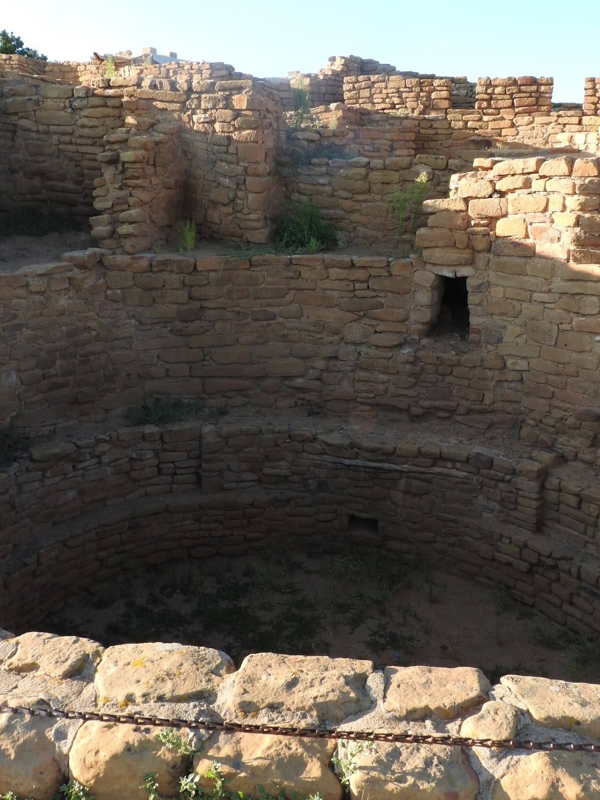
                                                                                                                                                        At Chapin Mesa, there is a nice museum dating back to the early years of the 20th century.  From there, you can walk a short way down to the Spruce Tree House cliff dwelling.  While Mesa Verde isn’t nearly as spectacular as Canyon de Chelly, the ruins are much more accessible.  You couldn’t climb on them, but you could get close enough to touch and to look into the kivas (circular pits used for ceremonial and domestic purposes.) While the inhabitants of Canyon de Chelly farmed the canyon floor and climbed up to their homes, the citizens of Mesa Verde farmed on top of the mesa and descended to their homes.  The canyon walls were not sheer and it was easy to access the alcoves where they built their dwellings.  In fact, the population originally lived
Museum at Chapin Mesa

Inside Spruce Tree House

                                                                                                                                            in pueblos on top of the mesa and only moved to the alcoves during the last hundred years or so before they left the mesa altogether.  The cliff dwellings were not inhabited for longer than we might inhabit a house today.

Spruce Tree House
View from Petroglyph Trail
Petroglyphs
After checking out the Spruce Tree House, I hiked the Petroglyph trail a mile and a half or so along the ledge containing the ruins to a spot where a number of petroglyphs had been carved into the stone.  It was an interesting path and I had to squeeze between boulders and climb up and down stairways made of stone or carved into the rock.  It gave me an idea what it would have been like to live in such a place.  After reaching the petroglyphs, the trail climbed steeply to the top of the mesa and then followed the edge of the mesa to the head of the canyon where it crossed above the Spruce Tree House and offered nice views of the same before returning to the museum.

Early Pueblo at Far View
Kiva at Far View
Far View Site
It was 6:00 by the time I got back to my car, but I had time to visit the Far View Sites, where there were older ruins from the pre-cliff dwelling period.  They were still impressive.  The inhabitants had even built a reservoir.  I made a quick circuit of the sites and then headed back down the hill to my camp where I cooked dinner and spent the evening writing about my experiences.  About midnight, I was awakened by a raging windstorm.  The tent was deforming and would have blown away had I not been holding it down.  I lay there for an hour or so until it calmed down enough that I could go back to sleep.

September 12, 2015
Pithouse Construction

It was a good thing that I didn’t need to rely on my cell phone alarm to wake me, since the battery had died during the night.  Unfortunately, I had been awake since 4:00, not wanting to get dressed and put my shoes on to go to the restroom, but too uncomfortable to sleep.  The whole campground must have been in the same predicament because at 6:00, everyone came alive.  I got up and made some of the coffee I had liberated from the Holiday Inn.  I ate breakfast and read for a bit until it was time to head up the hill to the Far View Lodge to meet up with my bus tour.  I had signed up for a four hour bus tour online.  The tour was conducted by Mesa Verde Guided Tours and it was very good.  The guide had lived in the park for about 50 years and was very knowledgeable.  He took us to different sites on Chapin Mesa and explained how the architecture had evolved from pit houses to pueblos to the cliff dwellings at the end of the occupation of Mesa Verde.   He took us to the Sun Temple, which was a very large complex that seemed to have been abandoned before its completion.

Sun Temple
We stopped at several overlooks to view cliff dwellings and our guide explained how the alcoves were formed when water percolated through the loose sandstone layer until it reached the impermeable Mogollon shale layer.  There, it worked its way to the face of the mesa and seeped out, taking part of the stone with it until an alcove was formed.  These seep springs came in handy for the cliff dwellers who were able to obtain water close to or even inside of their alcoves.  Mesa Verde has 600 cliff dwellings.  Most are just a few rooms and probably housed a single family, but some had up to 150 rooms and housed up to a hundred people.  The pueblo people did not view waste as garbage the way we do.  Everything they used came from nature and they believed that when they were finished with something, they had to give it back to nature.  Their garbage, human waste and even human remains were scattered down the side of the canyon in front of their pueblos, although the dead were buried.  Bodies were not considered garbage, but things that were no longer needed.
Cliff Palace

Eventually, our group joined a ranger led tour of Cliff Palace, the largest of the cliff dwellings and the one you usually see on postcards.  We descended a pathway carved by the Civilian Conservation Corps during the depression and then actually walked through the city before climbing out via a series of ladders that followed the original access route.  We could still see some of the hand and foot holds that had been carved into the rock.  The city was very impressive, with several towers and some “penthouses” on an upper level.  There were numerous kivas, the circular subterranean structures that served as ceremonial centers and living rooms for the inhabitants.  Being subterranean, they were warm in winter and cool in summer, so were perfect places to hang out and escape the harsh climate.

Cliff Palace from Inside the Alcove

No one knows why the people left about 1300.  There is no evidence of plague or war.  There had been a drought, but they had survived droughts before.  The most plausible explanation I heard offered was that some shaman decided it was time for them to move on.  The pueblo people have a tradition of migration, believing that they must learn to live everywhere before they may settle in one place.  The decision may have been influenced by food or water shortage or overpopulation, soil depletion, or unusual cold.

View from Lookout Point
Knife Edge Trail
   After the tour, I headed back down the hill to the campground.  On my way, I saw a bear ambling down the road.  I was sleepy.  I fried up some bacon for lunch, did my dishes, and took a long nap.  At about 4:00, I got up and went for a couple of the hikes leaving from the Morefield Campground.  First, I climbed up to Lookout Point.  The trail switchbacked up the side of the Mesa for a mile or so and then traversed the top of the Mesa to a point with a 180 degree view of the surrounding valleys and mountains.  It was clear and the view was pretty spectacular.  I charged up there and back in an hour, but it was a pretty good climb and could easily take twice that long.  After I returned to my car, I backtracked to the trailhead for the Knife Edge trail.  That trail follows the old access road along the side of the mesa for a mile before ending at a slide.  It was fairly level, but offered good views and lots of wild flowers and cottontail rabbits and deer.  I knocked the two mile round trip out in 40 minutes, finishing just before sunset.  Then I returned to my campsite, ate leftovers from the night before for dinner and spent the evening chatting with friends over the spotty WiFi connection and writing.

Thirsty Deer at the Pump Out Station