When I am not traveling, one of the things I enjoy doing is
hiking with a group called H.E.A.T. (Hiking Every Available Trail.) This fall, we took a group trip to Arizona to
hike the Grand Canyon and other trails in the surrounding area.
October 2-3, 2019
 |
| The Guest House I Rented in Needles |
 |
| The Interior of the Guest House |
I left home late in the morning and began driving to
Arizona. I hadn’t known what time I
would be able to leave, so I had rented an AirBnB in Needles, CA in case I
didn’t have time to drive to Arizona that night. As it was, I arrived in Needles about
dinnertime. I had rented a small guest
house at the rear of a property near the railroad tracks in Needles. The space was small and dark, but
comfortable. There was a kitchenette
stocked with food items available for purchase.
I had brought a cooler full of food with me and ate dinner in the
rental. The train tracks were very close
and the tiny house shook whenever a train passed which seemed to be every
twenty minutes.
 |
| Train Passing the House in Needles |
It wasn’t the most restful night I had spent. Long trains rumbled by every few minutes,
including one with screeching brakes at three in the morning. I didn’t have a terribly long drive left to
get to Flagstaff. I couldn’t check in
before our trip organizer arrived, so I tried to time my arrival to coincide
with his. I spent a leisurely morning
eating breakfast in my room and then practiced the guitar. By checkout time at 11:00, I was ready to
complete my drive to Flagstaff.
It wasn’t as long a drive to Flagstaff as I had
thought. I got there by 14:00. Stan had said he’d be there by 16:00, so I
settled down to wait. Gradually, the
members of our group began to arrive.
There were three women who planned to carpool with me while in
Arizona. They were due to arrive at the
airport at 17:30. Stan hadn’t arrived by the time I needed to go get them. I didn’t have room in my car for everyone’s
luggage, so I left mine in a friend’s car.
When we returned to the hotel, my luggage had gone to dinner. We, too, decided to go out and find food.
October 4, 2019

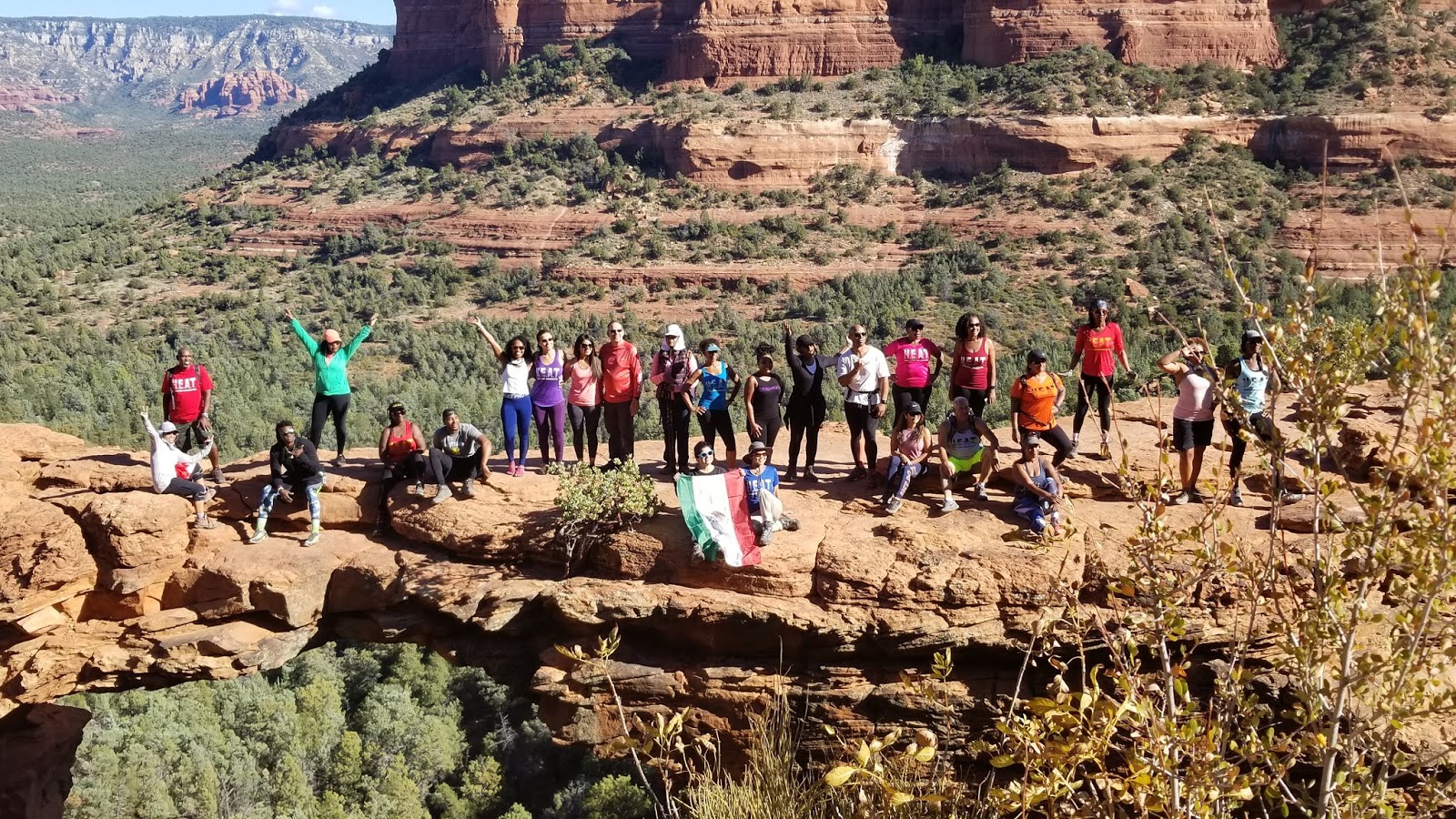
We got an early start on Friday morning and drove to Sedona.
Our first hike was 6 miles down and back along
a valley to the Devil’s Bridge where each and every one of us needed to be
photographed on the bridge, itself.
Hot
air balloons filled the sky across the valley when we first arrived and the
scenery was spectacular.
 |
| Broad View of the Devil's Bridge Area |
 |
| Our Crazy, Multicultural Group of Hikers |
 |
| H.E.A.T. on Devil's Bridge |
Our second hike was a four-mile circumnavigation of a rock
formation known as the Courthouse. It
was warm, but the hike was mostly level and we made good time.
 |
| The Courthouse |
 |
| Hiking Around the Courthouse |
 |
| Cathedral Rock in the Distance |
 |
| Kwame Hiking Up Fay Canyon |
Our third hike was up Fay Canyon to some sort of overlook.
The only trouble was that we missed the
overlook and kept picking our way up the streambed after the trail quit.
Eventually, we realized our mistake and
reversed our course.
We found the
lookout on the way back and the view was incredible.
 |
| Kwame, Suli, and Tarsha Where We Turned Back |
 |
| View from the Overlook |
 |
| H.E.A.T. Descending from the Overlook |
Tired and satisfied, we drove back to Flagstaff and a large
group of us ate dinner at a steakhouse where singing waitstaff entertained us
with selections from musical theater.
Then, it was back to the hotel to get as much sleep as possible before
our 4:30AM start time for our hike down into the Grand Canyon on the following
morning.
 |
| Singing Waitstaff in Flagstaff |
October 5, 2019
 |
| Early Morning at the Grand Canyon |
We left the hotel early, as planned, but the freeway was
closed and we somehow messed up the detour and ended up driving for miles on a
dirt road before we got back on track.
We got to the Grand Canyon Visitor’s Center parking lot just after 6AM,
but there were so many people opting for so many different hikes that it was
7:00 by the time we actually got organized.
Out of a much larger group, thirteen of us set out to hike to the bottom
of the canyon and back in one day.
Actually, only nine of us started out to do it, but we picked up an
additional four when we got to the trail that cuts across from the South Kaibab
trail to the Bright Angel trail.
We
convinced them it wasn’t that much further.
None of them had any trouble keeping up.
I left my car keys with the three women who had carpooled with me, since
none of them had opted to take the long hike.
I hoped they would drive around and pick me up at the Bright Angel
Trailhead.
 |
| Young Buck Facing Off with H.E.A.T. Men |
 |
| Elk Drinking from the Water Fountain |
We walked from the Visitor’s Center to the South Kaibab
trailhead, a distance of a couple of miles.
When we got there, elk were begging for water at the filling stations.
People were holding the faucets on so that
they could drink.
There was one young
buck with two skinny prongs for antlers.
He tried to attack the male members of our group but left the women
alone.
We had to keep a sharp eye on him.
No one wanted to hold the water on for HIM.
 |
| Hiking Down the South Kaibab Trail |
 |
| Cedar Ridge |
The hike down South Kaibab was steep.
I had hoped to be able to run, but it was too
rocky and there were too many stairs.
I
had to be careful not to fall, since it was a long way back up if anything
happened.
I made good time going down,
staying towards the front of the group.
We paused at Cedar Ridge to regroup and again where the shortcut to the
Bright Angel trail diverged.
We met a
group riding mules down to Phantom Ranch who had also paused there to use the
restrooms.
 |
| Mules Resting on the Way Down |
 |
| Later Stretch of the South Kaibab Trail |
 |
| Bridge Over the Colorado River |
 |
| Pack Mules Headed Uphill |
When I finally reached the Colorado River, I started across
the bridge to meet the few people who had arrived before me.
Halfway across the bridge, I was told by a mule
wrangler that I would have to retreat to the other side of the tunnel before
the bridge so that the train of pack mules
bearing luggage back to the rim could
pass. Apparently, mules have the right
of way no matter who starts across the bridge first.
 |
| The Colorado River |
We spent an hour or so beside the river, resting and eating
our lunch even though it was only 10:30 in the morning.
By 11:30, we had walked along the river to the
second bridge, crossed back over to the south side, and started up the Bright
Angel Trail.
I had started to feel a
twinge in my knee as I approached the bottom of the canyon but never felt it
again once we stopped descending.
 |
| The Lower Section of the Bright Angel Trail Was Not Steep |
 |
| The Last Four Miles Were Straight Up |
In the beginning, the Bright Angel Trail was not as steep as
the South Kaibab. It was a couple of
miles longer but ascended more gradually.
It was warm, but not excessively hot.
I had plenty of liquids and there were places to refill water bottles
along the way. The trail was quite
moderate as far as Indian Gardens where there was a watering station for the
mules. Past there, it got steeper. The last four miles switch backed steeply up
the face of the canyon. It was
relentless. Fortunately, that area was
in shade as the afternoon wore on and the temperature was pleasant. There were two rest stops with cute stone huts
offering shade and water.
 |
| Selfie Near the End |
Most of the way up, I had been in the rear with two other
women.
As we started up the switchbacks,
I was surprised to come upon our leader, Stan, walking slowly with another woman
who was suffering from altitude sickness.
I had begun to outpace my companions and, knowing they would be safe
with Stan, I left them behind and proceeded at my own pace.
I reached the rim of the canyon at 17:20.
There was no sign of my car or my friends, but I met another
member of our group who was waiting for Stan.
When I told him Stan was probably half an hour behind me, he was kind
enough to give me a ride back to the Visitor’s Center. There was a red Kia Niro plug-in hybrid
parked in the space where I had left mine.
However, it was not my car. Another
carload of women from our group reported seeing my friends at the Visitor’s
Center, but it was closed when I limped over there and they were nowhere to be
found. I was wearing shorts and it was
getting cold. My cellphone didn’t have
good coverage. It was a chilly hour until, via messages relayed
through others with different carriers, I was reunited with my car and passengers.
We started driving back to Flagstaff. It was apparent that the restaurants in Flagstaff
would all be closed by the time we returned.
We stopped in Williams to eat dinner at the Route 66 Bistro. We had to wait for a table, but the food was
excellent and went a long way towards rejuvenating my weary body. Fortunately, one of the other women who had
not hiked as far was able to drive. It
was 23:00 by the time we reached the hotel and we were supposed to leave by 5:30AM
the following day, which would have forced us to skip breakfast. Since none of my passengers had an early
flight, we agreed to visit Horseshoe Bend AFTER Antelope Canyon , which allowed
us to sleep an extra hour and enjoy the breakfast buffet at the hotel.
October 6, 2019
One of my passengers needed to get to Phoenix, so she
switched to a different car. The
remaining three of us left the hotel at 7:00 and headed straight to Paige, AZ,
where we were scheduled for a 10:15 tour of Lower Antelope Canyon with Dixie
Ellis Tours. It was a long drive and we
had a moment of panic when we realized that the Navajo reservation time was an hour
ahead of Arizona. Fortunately, the tour
companies observed Arizona time and we arrived in plenty of time.
 |
| Navajo Hoop Dancer |
Our tour began with a demonstration of the Navajo Hoop Dance.
The dancer competed regularly and put on
quite a show.
He danced in and out of
the hoops and rearranged them to form patterns such as baskets and butterflies.
After his presentation, we were divided into
groups of ten, each with our own guide.
Our
guide was a young Navajo woman who was very knowledgeable about both the canyon
and how to set our phone cameras to capture the best images.
 |
| Woman's Face |
We descended six flights of metal stairs to the bottom of
the narrow slot canyon.
Our guide showed
us a video of the last time the canyon had flooded.
It was completely filled and water was
splashing out over the rim.
The flood
had torn some of the stairs from their anchors.
Fortunately, there had been enough warning to get everyone out of the
canyon before the water arrived.
 |
| H.E.A.T. in the Canyon |
 |
| The Light Was Incredible |
 |
| The Seahorse |
 |
| Even I Wanted a Photo in the Canyon |
 |
| Stone Arched Above Us |
The canyon was amazing.
Every view was captivating.
It
was impossible to stop taking pictures.
I
generally eschew selfies but even I couldn’t resist having my picture taken in
that lovely reddish light.
Our guide
graciously took dozens of photos for us.
We gradually worked our way uphill along the 1300 feet of the canyon,
watching for the more famous of the rock formations.
By the time we emerged from the earth, we
were only a couple of flights down.
The
tour was one of the most worthwhile excursions I had ever taken.
It was well worth the $54 entrance fee and
advance planning necessary.
 |
| Emerging From the Slot Canyon |
 |
| Trudging Through Sand to Horseshoe Bend |
Once we regrouped at the car, we headed back down the road
to visit Horseshoe Bend which we had passed on the way.
At Horseshoe Bend, the Colorado River makes a
more than 270-degree bend.
We paid the $10
parking fee and slogged half a mile or so through sand to the edge of the
canyon.
It was warm and there was not a
scrap of shade.
We took a few quick
photos and returned to the car.
We still
had two hours of driving to reach Flagstaff.
 |
| Horseshoe Bend |
Once we got to town, we dropped one woman off at what looked
like a very nice hostel in downtown Flagstaff and then I took my remaining
passenger to the airport. Once free of
my riders, I turned west and headed down Highway 40 towards Kingman where I
would catch the road that would lead me to my friends’ home in Meadview, AZ.
I again got stuck in the freeway closure in Flagstaff for over an
hour, which put me behind schedule. My
friends were waiting dinner for me and I had hoped to arrive by 18:00. As it was, I didn’t get there until 19:15 and
had to make the drive from Kingman in the dark.
Cattle frequently wander across the road but I luckily didn’t encounter
any. Jan and Ramona served me a delicious
dinner of chicken mole and then we were all ready to call it an early night. I was exhausted after many days of early
mornings.
October 7, 2019
My friends lived in the Grapevine Mesa Joshua Tree Forest.
Their home looked out at the red sandstone cliffs of Grapevine Mesa, on the other side of which ran the Grand Canyon.
We didn’t do much on Monday.
Ramona had luncheon plans with a group of
women friends.
We met them for lunch at
the dining room of a local dude ranch.
A
guitarist entertained us with humorous songs.
 |
| The View from My Friends' Home |
Later, we strolled around the neighborhood at sunset and
then Ramona fed us again.
It was a nice,
relaxing day.
October 8, 2019
 |
| Pierce's Landing Where the Grand Canyon Ends |
Tuesday, Jan and Ramona took me on a drive around the
area.
First, we drove out a long dirt
road to Pierce’s Landing where all the rafters on the Colorado River pulled out
before reaching an impassable rapid.
We
parked at the landing and then hiked a mile or so along the river to get a view
of the rapid.
Both sides of the river
folded towards the center where they smashed into a large rock in the center.
I could see no path through that rapid.
The force of the water breaking over that
rock was tremendous.
After leaving Pierce’s Landing, we drove to the current shore
of Lake Mead.
The launch ramp had been
extended as the lake level dropped but the rumor was that it would be extended
no more.
Extended drought had let it’s
mark on the region.
 |
| The Launch Ramp at Lake Mead |
After seeing the sights, we returned to the town of Meadview
pick up mail and take a swim in the homeowners’ association pool.
As warm as it was outside, the water in the
pool was freezing.
I dove in but couldn’t
stay.
I leapt out of the water as fast
as I could to lie in the sun and warm up.
After our aborted swim, we stopped by the Chamber of
Commerce where local artists sold their crafts.
I bought a beautiful pair of silver and lapis earrings for a fraction of
what similar ones had sold for at Antelope Canyon.
I also picked up two sets of ceramic coasters
to replace the rather scruffy ones I had been using at home.
After another nice dinner, we sat down to a game of Scrabble. It was relaxing to spend time with friends
after dashing here and there with my hiking group.
October 9-10, 2019
 |
| Grapevine Mesa Joshua Tree Forest |
We got up early and took a walk before breakfast.
The Joshua Trees were lovely in the morning
light.
I left Meadview by 9:00 and began
my drive to Seal Beach to visit my friend, Diane.
It was a long an uneventful drive.
The weather was quite pleasant, unlike the
112 degree temperatures I had seen the last time I passed through the area in August
of 2018.
I arrived in Seal Beach by late afternoon and had time to
take Diane out for a birthday dinner at the Claim Jumper. I spent the night in her place at Leisure World. The next morning, we walked to a café just
outside the gates and had breakfast.
Then I hit the road again. I had
to get home in time to greet some AirBnB guests at my house. It was a quick trip up Highway 5, stopping
only long enough to buy gas and lunch.
My summer of travel was complete.
It was time to spend a few weeks at home before heading back to Mexico
in November.


 We got an early start on Friday morning and drove to Sedona. Our first hike was 6 miles down and back along
a valley to the Devil’s Bridge where each and every one of us needed to be
photographed on the bridge, itself. Hot
air balloons filled the sky across the valley when we first arrived and the
scenery was spectacular.
We got an early start on Friday morning and drove to Sedona. Our first hike was 6 miles down and back along
a valley to the Devil’s Bridge where each and every one of us needed to be
photographed on the bridge, itself. Hot
air balloons filled the sky across the valley when we first arrived and the
scenery was spectacular.