Thursday, May 16, 2024

BAHIA DE LOS ANGELES TO PUERTO ESCONDIDO

May 4, 2024

Leaving Bahia de los Angeles
We didn’t have a long way to go, so we didn’t rush out of the Bay of L.A. Still, we were underway by 9:00. We followed the southern shore as we left and passed the other side of the window into Puerto Don Juan. It was still quite cool, and we were in long pants and fleeces. There was a lot of red tide in the Bay of L.A. and this condition followed us around the corner into Bahia de las Animas.

Chocolate Frosted Mountains

The only boat we had seen in the Bay of L.A. proper was Starr E, which had been anchored off the village. Once we entered Bahia de las Animas, we didn’t see another boat. Bahia de las Animas is a few miles deep. Punta Islotes, where we planned to anchor, is at the far end of the bay. We motored along the shore past pink mountains capped with what looked like chocolate frosting. It seemed that a volcanic layer had covered the pink sandstone and then been gradually eroded away, leaving caps of brown on the tops of peaks and ridges.

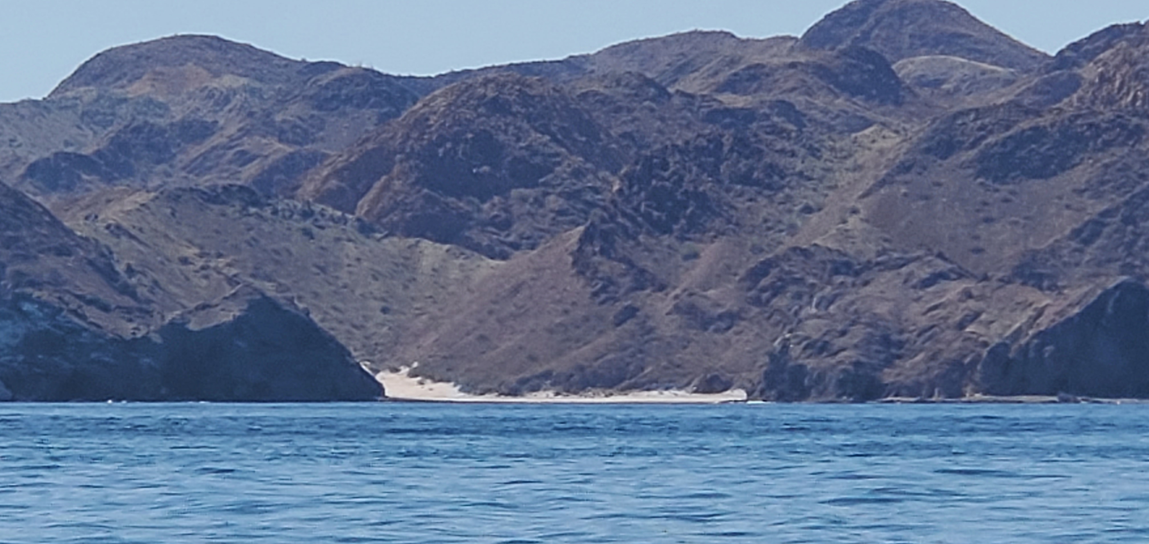
The Guano Looked Like Snow
The Punta Islotes anchorage lies behind some rocky islets and a sandy point. The islets were covered with tall, green cactus and brilliant, white guano. The guano looked like snow, which made the islets look like Christmas card photos. The area is known for bird watching and is supposed to be home to osprey, but we saw only handsome gulls that were happy to pose for portraits. A row of crab pots marked the edge of the anchorage and we had to dodge them as we kept a careful eye on the depth. The anchorage is small and shelves rapidly. I made a U-turn as soon as we registered a depth of thirty feet, but we still dropped the hook in 28 feet and the boat came to rest in 24 feet. By low tide, the depth was down to 19 feet.

Gull at Punta Islotes
The anchorage was sheltered, and we could finally feel the warmth of the sun. We warmed up all of our leftovers for lunch and then launched the dinghy. Launching the dinghy required me to winch it up off the deck with the spinnaker halyard while Brad guided it over the lifelines. I then lowered it into the water while Brad secured it to the boat and released the halyard. After Brad led the dinghy to the rear of the boat and secured it to the stern, I winched the motor up off its mount using a small crane attached to the stern. Brad grabbed the motor and swung it towards the dinghy while I lowered it. Once the motor was secured to the stern of the dinghy, we released it from the crane and stowed the block and tackle until it was time to reverse the process.

Entrance to the Lagoon
We were eager to explore the anchorage and surrounding area. While there was a lot of red tide in the bay, the water in the anchorage was fairly clean and sparkled a turquoise blue. The bottom was carpeted with colorful pebbles and shells. Initially, we motored the dinghy out to the islets at the entrance to the anchorage and visited the gulls. Then we made a stop at the sandy point. There had once been a fish camp on the point, but it lay in ruins. The point was separated from the land by a shallow lagoon. We wanted to explore the lagoon but decided it would be better to do so from the main beach. We got back in the dinghy and headed that way.

The Dinghy at Punta Islotes
The water got shallow quite a way from the beach and we were forced to get out and tow the dinghy. Eventually, we just anchored it. We probably should have dropped the anchor much sooner, as the tide was going out and we were later forced to carry the dinghy until we could float it.

The Lagoon Was a Breeding Ground for Crabs

The area around the entrance to the lagoon was sandy and the rapid tidal action sorted the sand and pebbles into distinct patterns. The bands of different colored stones looked manmade. The lagoon was a breeding ground for at least three different types of crabs, some of which were large enough to eat. It was hard to walk without crushing any of them. We waded around in the shallow water, watching the fiddler crabs scurry away with their single giant claws over their shoulders and the hermit crabs wearing pretty snail shells alternately dashing away and pretending not to be there. The tide was ebbing rapidly. The water was bathtub warm against our ankles.


Abandoned Panga on the Beach
There was an unoccupied fish camp on the shore and a motorless panga beached on the point. There were tire tracks in the sand, but we never saw another human. The area surrounding the lagoon supported more plant life than we had seen since San Juanico. There were even red and yellow leaves floating in the water.

The tide had dropped at least a foot while we were exploring, and our dinghy was high and dry. A dinghy equipped with an outboard makes a heavy load. We each hefted one side of the stern and dragged the bow across the pebbled bottom until we were finally able to float the dinghy. We walked it until the water reached our knees and then Brad rowed until it was deep enough to lower the motor for our return to the boat.

We enjoyed basking in the sun when we returned to the boat. It seemed like a long time since we had been warm. All the excitement of exploration had distracted us from preparing anything for dinner, so we made do with canned chili and quesadillas for dinner. We passed a perfectly calm night in our sheltered spot. There was not a single light showing anywhere in Bahia de las Animas.

May 5, 2024

I awoke at 5:00 and poked my head up long enough to see the beginning of the sunrise. It was too cold to venture outside, so I returned to my bunk and slept until 6:15. By the time I got up, the sun was already warming the cockpit. I made a hot mocha and went out to enjoy the scenery while I could. Punta Islotes had rapidly become my favorite spot in Baja, and I wished we could linger. I hated having to keep a schedule while cruising.

Coyotes by the Fish Camp
Before I was quite finished dressing, Brad called me out to watch coyotes on the beach. I had heard them yipping, earlier, and they were at it, again. We saw three of them. The tide was very low. They trotted along the beach to the sandy spot at the entrance to the lagoon where they spent over an hour hunting crabs. Gulls hovered, nearby, waiting to snatch any morsels they let drop. It was fun to watch them go about their business and the show added to the magic of the place. I was very sorry when we pulled up the anchor at 8:30 and motored past the crab pots and out into the bay.

Coyote Hunting Crabs
Brad went below to work on his computer, and I took the boat up the eastern shore of Bahia de las Animas and peeked into the other anchorages on the bay. All of them looked lovely, especially the Animas Slot just outside the mouth of the bay with its white sand beach. We rounded the point and set off across towards San Francisquito. Brad took over at 11:30 and I went below to eat lunch and write.

The Animas Slot

I came back on watch at 2:30. We had been making good time. About 15:00, we saw a couple of commercial fishing boat cross ahead of us. By 16:15, we had the anchor down at San Francisquito.

The Anchorage at San Francisquito

We hadn’t liked San Francisquito the first time we were there. It was cold and windy, and we hid inside the boat to avoid the bees. Our second visit was much more pleasant, but the bees were still a bother. I made chicken and diced tomatoes over rice for dinner, and we passed a quiet night.

May 6, 2024

Moonrise at Dawn
It was a long way from San Francisquito to anywhere. On our way north, we had left from Santa Rosalia and sailed all night so as to arrive in our anchorage during daylight. This time, we left the anchorage in the pitch dark at 4:00 and aimed for Caleta Santa Maria, which was about five miles closer than Santa Rosalia. We knew that Caleta Santa Maria was used to load gypsum onto ships, but figured we would arrive there after working hours.

It was very calm in the morning, but the wind gradually increased until we were seeing twenty-two knots. The wind also kicked up the biggest waves we had ever seen in the Gulf of California. We were screaming along at seven knots.

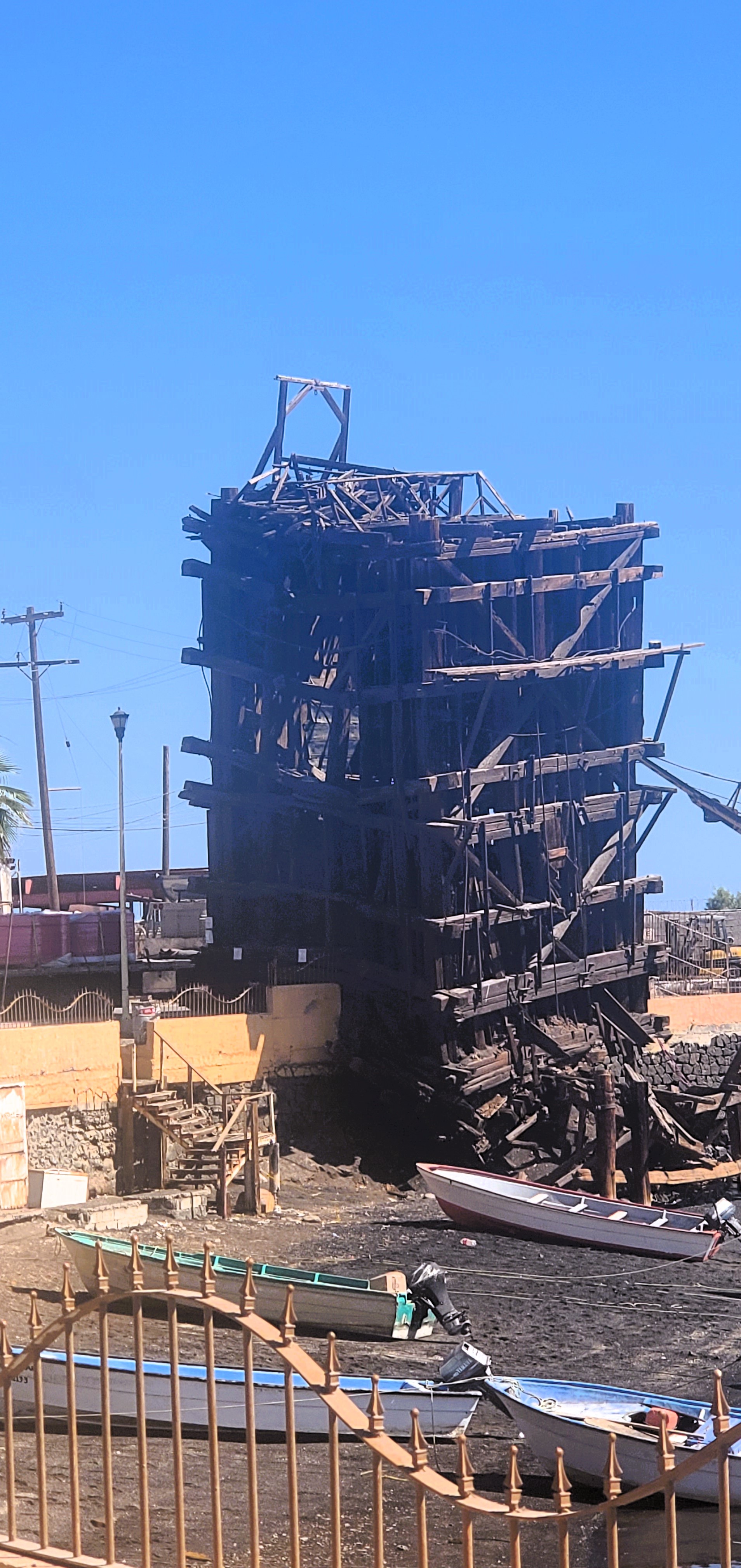
The Mining Operation at Caleta Santa Maria
We reached Caleta Santa Maria at 15:30 and were dismayed to discover that the new copper mining operation out of Santa Rosalia had taken over the area. We could see huge machinery on the breakwater and a cloud of dust arose from the mine just behind the cove. We didn’t want to go anywhere near that dirty cloud. We decided to press on to Santa Rosalia.

The wind continued to howl, and the waves tossed White Wind. We had reserved a slip in the marina but didn’t want to try to enter under the reigning conditions. We made the decision to anchor in Puerto Viejo at the south end of Isla San Marcos.

Sunset Over Isla San Marcos
The wind abated, somewhat, as the sun set. We continued another twelve miles down the outside of Isla San Marcos. Unfortunately, we did not make it to the anchorage before dark. There was a new moon, and it was black as ink. Never have I made a landing with quite so much dependence on the instruments. We had to pass between two reefs into the shallow anchorage. Brad was on the bow and was hollering at me every time a significant wave knocked me off course. We were bouncing all over the place and it was quite stressful. Finally, we dropped the hook in fifteen feet of water, not really knowing how far we were from shore.

It was 21:00 by the time we finished anchoring. We were cold and hungry. Our friends, Blair and Mikey, had invented a dish they call momo fuko ando, after the inventor of ramen. The original recipe involves stirring eggs into the soup made from ramen packets. We only had Cup O’ Noodles, but I measured the water into a pan, dumped the contents of the cups into the pot, and stirred in the eggs. It was a hot a filling meal and welcome after a very long and somewhat harrowing day. The anchorage was reasonably calm and we slept well.

May 7, 2024

Puerto Viejo Anchorage
I was quite curious to get a look at the anchorage when I woke up. The guidebook made it sound like an ugly place, but I thought it displayed an austere beauty. Bare, rocky cliffs rose from the water and formed a crescent which was continued by rocky reefs on both sides of the anchorage. It wasn’t a deep bay, but the whole of Isla San Marcos sheltered it from north winds. The water was glassy in the morning.

We didn’t have far to go to our next stop at Punta Chivato, but I had a What’s App meeting scheduled for noon, so we got an early start. The seas were calm in direct contrast to the previous day. We arrived at Punta Chivato by 11:15.

Abandoned Hotel at Punta Chivato
I had been trying to get to Punta Chivato for years. It was a beautiful place. The anchorage was shallow with turquoise waters. It was lined with expensive homes featuring extensive landscaping and stonework. There had once been a hotel on the point, but it was shuttered. It appeared to have suffered a great deal of storm damage. Most of the palapa roofs covering individual patios were collapsed. Punta Chivato is difficult to reach by road but offers an air strip. Most of the homes were unoccupied. We only saw lights in a couple of them at night.

Fancy Homes in Punta Chivato
Punta Chivato would have been a great place to go ashore or swim, but it was too cold and windy to tempt us to do either. Unfortunately, Starlink didn’t work very well there, either. I barely managed to participate in my call and completely failed to connect to the website to work on my blog. We spent the afternoon reading and catching up on sleep. For dinner, we ate the leftover chicken and rice.

May 8, 2024

San Sebastian
We motored out of Punta Chivato at 7:30 and set off for San Sebastian, where we hoped to spend the night. Seas were calm and we made good time. We arrived at San Sebastian about 14:45. San Sebastian is a tiny oasis containing a handful of nice homes. The cove is small, and our guidebook warned us that private moorings left room for only one cruising boat at a time. We didn’t see any boats in there, so we proceeded to enter. It was tight, shallow, and the sea floor sloped up quickly. Brad wanted to go in to fifteen feet in order to get good shelter. When we reached fifteen feet in the area that was reputed to be open, there was a mooring right where we wanted to drop the anchor. It was already too shallow to go in further, so I made a rapid U-turn and we headed back out to sea. We came and we saw but we failed to conquer San Sebastian. The residents had made it impossible for cruisers to anchor in their cove.

Pulpito from the North
Fortunately, it was only another twelve miles to Pulpito, our next scheduled stop. We could see the massive plug of basalt in the distance. From far away, Pulpito appears to be an island. It is connected to the land by a low, sandy point that is hard to see from a distance. We had planned to anchor at the base of the cliff, but a swell was coming from the southeast that might have made the anchorage uncomfortable. We elected to anchor in the more western of the two coves north of the rock and tucked White Wind behind a small point in fifteen feet of water.

The Anchorage North of Pulpito
Finally, we were warm. It was lovely in the cockpit. I could finally shed my long pants and long-sleeved shirt. I made spaghetti and we ate outside in the cockpit. I sat out there until 21:00, enjoying the evening, even though there was still no moon and it was black dark.

By 21:00, a strong wind began to blow offshore. It probably wasn’t blowing more than fifteen knots, but it howled through the rigging and made the boat creak and the anchor snubber squeak against the hull. It was disconcerting because it was so dark I couldn’t tell which way we were pointing. Fortunately, there was one other boat in the anchorage and I could tell that its anchor light remained in the same position. I finally had to leave my bunk in the forepeak, put in my earplugs, and move to the salon. I was comfortable, after that.

May 9, 2024

Pulpito
Once again, it was calm when we left the anchorage at 7:45. Brad wanted to see Pulpito, so I piloted the boat around the point to the anchorage on the other side so he could get a good look. We took some photos and then turned the boat to head for Isla Coronados.

Soon, the wind picked up enough for us to sail for an hour or so. We were only making about 3.5 knots, but it was nice to get a break from the engine noise. Brad took the helm at 10:30. When our speed dropped below three knots, he cranked up the engine, again. I went below to write and catch up on some of the sleep I had missed the night before.

Isla Coronados
I came back on watch at 13:30. By then, we were motoring down the east side of Isla Coronados. We saw a big pod of dolphins passing by, but they didn’t want to play with us. Isla Coronados is obviously a former volcano with the classic conical shape. The west side had collapsed at some point, forming a shallow bay in which to anchor. We had been experiencing strong winds out of the west during the night, so decided to anchor on the less scenic, but more sheltered east side. We put the hook down in twenty feet of water before 15:00.

Anchorage East of Isla Coronados
We had just finished securing the anchor snubber when a large motor-sailer approached the achorage. They were 56 feet and needed a lot of space. We had anchored pretty much in the center of the small bay and I couldn’t see anywhere for them to go that wouldn’t be too shallow or too close to us. We watched them carefully and must have made them feel unwelcome because they turned around and headed for the other side of the island.

We were out of almost everything, so ate the last of the leftover pasta for dinner. We looked forward to reaching Puerto Escondido and going out for pizza, not to mention taking hot showers.

May 10, 2024

Dawn at Isla Coronados
I awoke at 4:51 when a strong wind started blowing out of the northeast. We had been expecting winds
from the west during the night and this was surprising. I tried to go back to sleep but never did manage to do so. I finally got up about 5:15.

We didn’t have far to go and weren’t in any hurry. We left the anchorage about 8:00 and decided to do one-hour watches since we expected to be back at our mooring before 13:00. I took the first watch because I was already at the helm. I tended to drive when entering or exiting anchorages because Brad was on the bow manning the anchor windlass.

Puerto Escondido
Brad took over at 9:00 and we sailed until the wind petered out. I drove from 10:00 to 11:00 and then we sailed a bit more until we needed to turn into Puerto Escondido. Once more, I took the helm while Brad dropped the main sail. I piloted the boat through the narrow entrance and up to our mooring ball. Brad successfully grabbed the hawser on the first try. We had left a buoy with the boat’s name attached to our mooring ball. Progress One was still on the adjacent mooring, Blair commented that someone had come by in a dinghy about 30 minutes before we arrived and asked why the mooring seemed to be reserved. Blair told him that we’d be back shortly and would be pretty annoyed if someone had taken our mooring. Brad had paid for the entire month of May.

We were glad to be back in civilization. After eating a quick lunch, we launched the dinghy, packed up our laundry, and headed for shore. We did three loads of laundry and took showers before meeting Blair and Jim from Brainwaves for dinner at the restaurant. We had a leisurely meal and caught up with our friends. In the evening, I had a chance to finish a blog post before heading to bed.


Friday, May 10, 2024

PUERTO ESCONDIDO TO BAHIA DE LOS ANGELES


Puerto Escondido in the Morning
April 24, 2024

With a 38-mile journey ahead of us, we wanted to depart Puerto Escondido as early as possible. When I emerged from my cabin at 6:30, Brad had already taken the dinghy to shore to do one last load of laundry. The laundry room was scheduled to open at 7:00, but Brad had to wait until 7:30 because the key had been misplaced. Still, he was back at the boat before 9:00. We hauled the dinghy back onto the foredeck and departed. Blair and Ray had left, earlier, to hike up Tabor Canyon. We observed Wings entering the bay as we approached the channel and Fred called to say goodbye. 

The Anchorage at San Juanico
It was another very calm day. We motored out the channel and then turned north and headed up the coast. It was interesting to see the “windows” in Puerto Escondido from the other side. All day, we kept hoping to see enough wind to sail, but it never materialized. With the water as flat as it was, we were able to motor at 6 knots, so we made good time. We passed Isla Coronados and dropped the hook in San Juanico by 16:30. I cooked tuna steaks with beans and salad for dinner. We had missed our naps and were both sleepy. It was all I could do to stay awake until 21:30. There was no wind, but the boat was rolling a bit when I went to sleep. I feared it might get worse, but it did not. 

 April 25, 2024 

Morning in San Juanico
When I awoke at 00:30, it was perfectly calm, and I went right back to sleep. However, when I awoke,
again, at 3:15, the wind was howling off the beach. I got up to be sure we weren’t being blown onto a lee shore and then went back to sleep. Our bow was headed into the wind, so the motion wasn’t uncomfortable. The squeaking of the snubber lines against the hull woke me repeatedly, all night, and I didn’t get up until 7:00. Brad and I were both a little bleary. It was a two-coffee day for Brad. 

Cruisers' Shrine
We didn’t get moving until nearly 10:00 when we lowered the dinghy into the water, installed the motor, and went to shore to explore. I wanted to show Brad the cruiser “shrine” where, for years, boaters had left mementos of their passing. Don and I had left a shell painted with Comet’s logo years before, but I couldn’t find it. We did see ornaments left by other acquaintances. The shrine is a scrubby tree festooned with shells and other items. The display is exposed to the elements and is ever changing.


The Supposed Walton House
There is a complex of houses on the cliffs overlooking the cove. According to one book I read, the original house was built by a Spanish countess. A sailor we met told us it was currently owned by the Walmart heirs and that they paid to maintain the campground on the beach. We hoped this was true. Someone was clearly maintaining it and removing the garbage. 

Freshwater Lagoon at San Juanico
After we left the beach with the shrine, we motored over to the beach on the other side of the cove and anchored the dinghy there while we went ashore. Behind a sand berm, we found a freshwater lagoon. Earlier, we had seen a herd of horses walk along the beach and disappear in the direction of the water. 

We motored back to the boat and spent the afternoon lounging. We had a lovely lunch of leftover tuna steaks, penne with pesto, and salad. As the sun was setting, we saw a lone burro return from the canyon with the lagoon and pick his way along the beach and across the rocks at the bottom of the cliffs to climb up the steep hill towards the road. We wondered where he was headed. The full moon rising over the anchorage was spectacular and I sat outside to admire it. 
Moonrise Over San Juanico


April 26, 2024 

Sunrise in San Juanico
We had 42 miles to go to get to Bahia Concepcion, so we left early. The sea was very flat, and we made good time. Within an hour and a half, we had passed Pulpito, a giant plug of igneous rock rising out of the sea. We planned to visit it on our return trip. 
Pulpito


It got windier and windier as the day progressed and we sped towards Bahia Concepcion on main alone, as the wind was on our nose. We squirted around the corner into the bay and dropped anchor at Punta Santo Domingo about 15:00. The anchorage was sheltered from the swell, but not the wind. We anchored off the beach in fifteen feet of water. We saw no trace of the mountains of scallop shells that had littered the beach in 2016. 

Anchorage at Punta Santo Domingo
Brad grilled arrachera for dinner and we ate it with beans, tortillas, and salad. One other boat joined us before sunset. It was quite calm by that time. The wind never came up during the night which allowed the boat to lie crosswise to the swell. We rolled badly. Between the motion of the boat and the yipping of coyotes, we slept badly. 

 April 27, 2024 

Despite not being in any rush, we were both up by 5:45. We were still rolling too much to really enjoy our leisurely morning. By 9:00, we had pulled anchor and headed off to Playa Santispac. There was a pleasant wind, and we were in no hurry, so we tacked up the bay under sail until the wind died just in time for us to make the turn into Santispac. 


Beachfront Home in Playa Santispac
There were more houses on the beach than there had been when I was there in 2016, but the campground and restaurants were unchanged. The water was still a startling turquoise. We anchored in the lobe of the bay near the houses, rather than the campground. It was perfectly calm. We put the dinghy in the water and motored over to the wide, sand beach that contained the campground. We tried to go to Anna’s restaurant, but found it shuttered. We walked back to Armando's 
restaurant and sat there long enough to drink margaritas. Then we motored back towards the boat, stopping at another little, sandy crescent accessible only from the water. The water was quite warm, but the air temperature did not invite us to swim. It was a shame, as the water was gorgeous.
Anna's Restaurant
 
Back at the boat, we munched on guacamole and chips which filled us up so much that we delayed eating dinner until after 19:00. We made tacos out of all our leftovers, managing to dirty every bowl in the boat in the process. The anchorage was so still that Brad remarked that it felt like we were in an RV in a parking lot. The moon was not due to rise until after my bedtime. I retired at 21:00 and slept blissfully. 

The View from Armando's


Brad Wading at Playa Santispac


April 28, 2024 

Palapas on the Beach in El Burro Cove
We had slept so well in our protected anchorage that we both arose by 6:00. We made beverages and sat in the sun in the cockpit. It was warm enough for shorts and T-shirts by 7:00, although it cooled off fast once the wind came up. 

We didn’t have far to go. Still, we pulled up the anchor and headed around the corner by 9:00. I wanted to see if the palapas on Playa El Burro were still standing, so we headed there, first. Geary’s huge ham radio antenna was gone, but the area seemed otherwise unchanged. Several boats were anchored there. We decided to anchor in Playa El Coyote, just around a rocky point from El Burro. The water was beautiful, but it was cool and windy all day. We had chosen that anchorage for its restaurant and grocery store, but it was too lumpy for us to want to put the motor on the dinghy. We spent all day lounging around the boat. I read, studied French, and wrote. We contemplated our itinerary and Brad talked on the phone. My phone had become unmoored from its network and refused to find it again, despite being a Telcel phone. We wanted to call the marina at Santa Rosalia but they were closed on Sundays, anyway. We made rice and cooked pork chops for dinner. The wind died as night descended and we slept peacefully. 

Shoreside Homes in Playa El Coyote


April 29, 2024  

Leaving Concepcion Bay
Once again, we were up at first light and pulled out of the anchorage at 7:30. The morning was calm and we motored out into the main portion of Bahia Concepcion, keeping our eyes on Navionics and the depth sounder. The Ray Marine chart plotter was quite inaccurate in the Gulf of California and there were many shoals. It took us a couple of hours to clear the bay. 

We chose a route outside of the Islas Santa Ines and Isla San Marcos and stayed in deep water. There wasn’t very much wind. We pulled out the sails but most of our propulsion came from the motor. We arrived in the marina at Santa Rosalia just after 16:00. This gave us time to check in before the office closed at 17:00. 

The Marina at Santa Rosalia
The marina was pleasant in several ways. Foremost, we were able to get a slip, right away. We were pleasantly surprised to find that the nightly fee was only 14 pesos per foot per night, what our friend, Blair, proclaimed was the lowest rate in the Western Hemisphere. On a quarterly basis, that rate dropped to a mere 10 pesos per foot. The docks were clean and the security guards and office staff helpful. We felt like welcome guests, possibly because the marina was small and not very busy. The standard prefab Fonatur buildings housed the local bus terminal and a brew pub. A large group of cruisers was playing dominoes in front of the brew pub when we passed. 

Malecon in Santa Rosalia
Brad and I took a walk down the malecon and remarked the absence of the usual waterfront tourist development. Prime real estate was devoted to such mundane businesses as auto parts and convenience stores. We bought some coffee in one of the shops and then, realizing that the center of town was in the other direction, returned to the boat. It was hot and we hid below decks until the sun sank low. 

About 19:00, we headed into the center of Santa Rosalia. Santa Rosalia was established as a company town by a French copper mining concern eventually known at El Boleo after the little green balls of copper ore that were discovered there in 1868. Originally, the executives lived on the mesa north of town and the workers lived in the central area in the arroyo below. Most of the town lies in that arroyo with a few homes on the southern mesa and homes and a hotel on the northern one. The town does not resemble a Mexican town. The style of architecture resembles any nineteenth century mining town in the United States with wooden houses sporting covered porches and surrounded by picket fences. The few stone buildings were constructed in a French style. 

We ambled around the central neighborhood, observing the architecture and looking for a restaurant open on a Monday night. We finally selected one across the street from the gymnasium where a girls’ basketball game was in progress. The town was lively for a Monday night and vehicular traffic was heavy. Everyone seemed to be driving nice, new cars. 

Santa Rosalia Architecture
While Santa Rosalia had languished after the original copper mines shut down in the 1980s, a joint Canadian and Korean firm had resumed mining for copper, cobalt, and zinc just north of town in 2016 and the town appeared to be prospering. We were back at the boat by 20:30 and, having arisen early, quickly retired. 


April 30 – May 1, 2024 

Mining Museum in Santa Rosalia
I awoke at the crack of dawn and lay in bed for an hour or so until I started receiving messages and could tell that Brad had turned on the Starlink. I got up and tried to take a shower. I was only moderately successful as there was no hot water in the marina restroom. Brad was drinking coffee when I returned, and I made myself a cup. We surfed the internet and answered messages for a while and then I made some oatmeal with raisins. At 9:00, we gathered our shopping bags and set off along the waterfront towards the Ley supermarket. Along the way, we noticed some historical plaques outside the openings of mine shafts. We crossed the road to read the history of mining in Santa Rosalia. 

After copper was discovered in Santa Agueda in 1868, the site was sold to some Germans. Mining, there, only lasted a few years. In 1885, some French investors (the Rothschilds among them) signed a contract with the Porfirio Diaz government and established the Compagnie du Boleo and began mining in Santa Rosalia. They had to pipe water from nearby Santa Agueda to supply the town. Santa Rosalia still suffers from a shortage of water. There was no water on the docks when we arrived, and we were told this was also true in the town. 

Interior of the Eiffel Church
The Compagnie du Boleo built Santa Rosalia and eventually purchased the prefabricated steel chapel known as the Iglesia Santa Barbara from Eiffel after he had exhibited it in Paris. The church was disassembled and re-erected in Santa Rosalia where it stands to this day. Its lovely stained glass windows contrast with the interior framework which rather resembles an aircraft hangar. A new mine known as San Luciano was opened in 1931 and the ore transported via 18 miles of narrow-gauge steam trains to the foundry in Santa Rosalia. 

Ruined Foundry in Santa Rosalia
We passed the ruins of the foundry on our way to the grocery store and had nearly finished exploring the facility, which was alarmingly hazardous, before we encountered the docent, Kilos, who showed us around the ruins and answered many questions. The ore was first crushed and then smelted in giant ovens. The molten ore was formed into ingots which were shipped across the Gulf to Guaymas and then transported to New Orleans via rail before being
The Smelting Ovens in Santa Rosalia

The Floor Housing the Generators

Leaning Scoria Tower
Remains of the Conveyer to the Tower
shipped to France. The byproducts of the process, a black, rocklike substance known as scoria, was carried by conveyor belt across the railroad tracks to a tower in the marina where it was loaded onto barges and dumped into the sea offshore. The black sand beaches in the area are comprised of this material. We had been very curious about this tower which now leans precariously. According to Kilos, the government was allowing the tower to collapse rather than allocating funds to repair or remove it. 

Another byproduct of the smelting process was steam, which was used to turn generators that provided electricity to the town. 


Brad and Me Exploring the Foundry

The Foundry Building and Former Office & Warehouse

Original Mine Steam Engine
The grocery store was just past the foundry and up the hill. We bought a few supplies and then walked back to the center of town where I took a few pictures. By this time, it was after 11:00 and rather warm. We stopped at a modern coffee shop and drank frappes on the shady front porch. It was a welcome break from trekking along in the blazing sun. 

Back at the boat, I rested my poor, sprained foot while Brad went out to visit the liquor store, fill a jerry can with diesel (the fuel dock was not operational), and check out of the marina. I tried to complete a blog post, but the Starlink refused to stay connected. I had to settle for writing about Santa Rosalia. We planned to leave that evening for an overnight trip to Bahia San Francisquito. 

The Harbor Wall
Our slip was deep into the marina and the area surrounding it was shallow at low tide. The height of tides had gradually increased as we ventured further up the Gulf of California. (Americans have long referred to this body of water as the Sea of Cortez. Mexicans prefer the title of Gulf of California, as Cortez conquered the indigenous peoples of Mexico.) We were afraid we wouldn’t have enough water to complete the turn if we were to back out to port and then proceed forward out of the marina. Instead, we recruited line handlers to pull the bow to port as we backed out, allowing us to back all the way out of the marina. 

Sunset North of Santa Rosalia
We left our slip at 18:00 and started north up the coast. We went as fast as we could, hoping to get as far as possible before the strong offshore winds began to blow. The first couple of hours were calm and we made it past the first low spot in the mountains without getting battered. By 21:00, the winds were blowing in earnest. The wind was on our beam, which was good for sailing, but the resulting swell caused us to roll. At least we weren’t slamming. The worst part of it was the cold. We had everything but our foul weather gear on and were still cold. 

Brad had the watch from 21:00 to midnight. The wind ranged from the high teens when I went to bed (not that I slept) to the low twenties when I took over. Below decks, it sounded like the boat was about to blow apart. Something in the boom rattled fiercely and the boat creaked as it usually did. Once I emerged into the cockpit, it was apparent that everything was fine. The wind was strongest from midnight to 1:00 and then gradually tapered off until it was a pleasant ten knots or so when Brad came back up at 3:00. He had been able to get a little bit of sleep. By morning, when I got up at 6:00, the seas were calm and glassy, again. Brad stayed on deck and snoozed in the cockpit while I took over the driving. 

The Anchorage at San Francisquito
We pulled into San Francisquito about 8:00. It was a desolate place. It remained cold and windy all day. We never bothered to launch the dinghy. There is a small inlet in the corner of the bay that would have offered better protection, but it was too shallow for us to go in and out except at high tide. We didn’t want to chance it. Reportedly, there were some services there, but we never went ashore. We spent the day catching up on sleep and I took advantage of the downtime to work on a blog post. I made spicy chicken wings for dinner, and we ate them with leftover rice. Our cucumber salad had frozen in the back of the refrigerator and was a total loss. 

The wind blew off the beach at night but not hard enough to alarm us. I awoke to light streaming in the hatch over my bunk. I assumed it was the moon and rolled over. When I awoke a few hours later, the light was still there. This seemed unlikely to me, so I altered my position and tried to focus my nearsighted eyes. The light was round. The moon would have been less than half full. One of us had accidentally turned on the deck light and it had been burning all night. I got up and shut it off. 

 May 2, 2024 

Leaving San Francisquito
We were eager to reach our goal of Bahia de los Angeles. We were up before 6:00 and hauling the anchor by 7:00. We motored up the channel between Isla San Lorenzo and the Baja peninsula. In the distance, we could see Isla Tiburon, the largest island in the Gulf of California. The gulf was so narrow at this point that it seemed we would have been able to see the other side if it were not for the haze lingering over the water in the morning. We debated where to go next. We had originally planned to stop at Isla Partida (not the one near La Paz), but we were concerned that we might miss our weather window to enjoy the Bay of L.A. if we dallied. We decided to push on to Puerto Don Juan near the opening to the Bay of L.A. 

Isla Angel de la Guardia
There was very little wind during the day, and we proceeded north at nearly six knots. We raised the main for stability, but it did little to propel us. We passed Isla Partida and the horizon filled with the mountains on Isla Angel de la Guardia. We peeked into Bahia las Animas, but elected to save that anchorage for the way back when it would offer us protection from the offshore winds. After passing a few more points of land, we made a U-turn around a point and slipped through the narrow channel into Puerto Don Juan. 


Puerto Don Juan is almost completely surrounded by rocky volcanic shores, leading me to believe that, like Puerto Escondido, it had once been the caldera of a volcano. Also, like Puerto Escondido, it featured a “window” through which we could see islands in the Bay of L.A. proper. It was a pretty spot.

Brad & Rene in the Bay of L.A.
We launched the dinghy but, after we had a celebratory glass of wine and took a selfie to celebrate having reached our goal, we didn’t feel like going ashore. It was still rather cold. We had spent the entire day in long pants and long-sleeved shirts. It certainly didn’t feel like May in Baja. We lounged and enjoyed the scenery. I tried to write, but the battery in my computer was dead and required charging. I read a Wilbur Smith novel, instead. We could barely be bothered to eat dinner, but Brad eventually grilled some pork chops while I made spaghetti with the last of our pesto stretched with butter and parmesan cheese. We passed a very calm night. 

May 3, 2024 

Shells at Puerto Don Juan
Morning in Puerto Don Juan


As usual, we were excited to explore and arose by 6:00. The anchorage was glassy at dawn. I took a few pictures and then heated water for our morning beverages. After Brad had his coffee, we decided to go ashore to explore before breakfast. First, we headed for the sandy beach. It was littered with clam shells and another species that looked like small conchs. We wandered around, taking pictures. The ocotillos were thinking about blooming but weren’t quite ready to grace us with their crimson glory. I spied a cholla, which kept me from venturing off the path which led across an isthmus to the other side. I declined to follow it to its end on account of my sprained foot. Brad had gone the opposite direction, anyway, and I headed that way. 
Brad on the Beach


The Beach at Puerto Don Juan


Brad on the "Window"


When we had our fill of exploring that shore, we hopped back in the dinghy and motored over to the “window” to try to determine if it was manmade or natural. It was perfectly level on top, which made it seem unnatural, but was comprised of thin pieces of volcanic shingle. We decided it was natural although I had no idea how it had ended up there. 

We had
Shingle on the Window
intended to get a move on after our exploration but were visited by Gary from Trinity and spent an hour chatting with him about cruising in the northern part of the Gulf of California. Then Brad spent an hour or so unclogging our septic line so that we could pump our holding tank overboard when we got far enough offshore. The macerator pump had been refusing to start and we feared it needed replacing, but that was not the case. Brad was able to use the vacuum to blow enough gunk out of the hose to get it working. The hose would need to be cleared or replaced when we were somewhere with access to parts. 

By noon, we were finally ready to leave Puerto Don Juan. We raised the anchor and motored back out of the anchorage, following our inward track. Once in open water, we headed into the Bay of L.A. and motored past Isla Cabeza de Caballo (Horsehead Island) and then between Isla Bota (Boot Island) and Isla La Ventana (The Window Island.) As we passed La Ventana, we saw the small arch that gave it its name. It looked like a mini Cabo San Lucas. We had wanted to stop for lunch in the anchorage on La Ventana, but it was very shallow and very windy, so we decided to play it safe and continued on past Isla Flecha (Arrow Island) and made for the village. 

The Window on Isla La Ventana
On our way to the village, we could see Punta La Gringa where the proposed land bridge from La Rosalillita would have reached the Gulf. It was proposed that there be a paved road from the Pacific to the Gulf through this gap in the mountains that would have allowed sailboats to be trucked across, thus saving 900 miles of chilly and often rough passage. A small marina was constructed at La Rosalillita, but the project was swiftly abandoned and the marina allowed to fill with silt. 

The village lay on the other side of a sand bar marked with a light tower. We contemplated going there for lunch but the water was dirty and a bit smelly and the town didn’t invite us. We cruised through the anchorage behind the sand bar and then headed across the bay to La Mona where we anchored off the beach in 24 feet of water. We were surprised to find substantial houses built on the beach at La Mona. The area is known for coyotes and whale sharks and we had expected it to be uninhabited. The water was cleaner than at the village, but was suffering from a red tide and wasn’t a pretty blue. Still, we were tired and just wanted to relax. Brad ate lunch and took a shower while I sat down to write and munch on smoked gouda and crackers. We certainly hadn’t explored the bay thoroughly, but we felt like we had gotten a good overview. Brad grilled hamburgers for dinner which we ate with salad and leftover rice. 

The La Mona Anchorage
Our anchorage never saw any wind, that night, but did get a small swell from the wind further north. The boat lay perpendicular to the swell, so didn’t roll, but the lapping of the water against the hull and tethered dinghy kept me awake most of the night. Only two of the many homes along the beach showed a light.
La Mona at Sunset